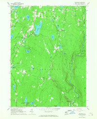
Old Maps of Forestburgh, New York for Hiking & Exploration
Hike through history with 65 historic maps of Forestburgh. Explore old trails, ghost towns, and forgotten backroads — perfect for outdoor adventurers and local explorers.
- Rediscover forgotten places: Map out old mining camps, roads, and footpaths that no longer exist on modern maps.
- Layer with modern tools: Combine with LiDAR or satellite views to plan hikes through historical terrain.
- Made for exploration: Popular among hikers, overlanders, and local history lovers.
Use these maps to find adventure and explore the hidden past of Forestburgh.
Forestburgh, NY maps
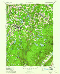
(65)- 1906 Map of Port Jervis, 1956 Print
 1906 Port Jervis1956 Print · USGSPort Jervis sits at the confluence of the Delaware and Neversink rivers during the height of the railroad era. Genealogists and local historians can trace the paths of the Erie RR, find vanished hamlets like Logtown, and locate the Old Bolton Basin along the river.
 - 1908 Map of Port Jervis
 1908 Port Jervis1908 Print · USGSThe tri-state border region comes alive at the start of the twentieth century, focused on the rail-and-river hub of Port Jervis. Genealogists and historians can trace family locations across Matamoras, Unionville, and Westtown, or locate landmarks like Tristate Rock and Old Bolton Basin.4 unique versions available
 - 1909 Map of Monticello, 1956 Print
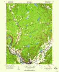
 1909 Monticello1956 Print · USGSSullivan County at the dawn of the twentieth century was a landscape of rail-connected resort communities and developing water systems. Researchers can trace the routes of the New York Ontario and Western RR to historic stops like Hurleyville Luzon Sta or the secluded Hartwood Club.
 - 1911 Map of Monticello
 1911 Monticello1911 Print · USGSSullivan County at the height of its early resort era shows a landscape shaped by competing railroads and mountain valleys. Genealogists and historians can trace the New York Ontario and Western RR through Hurleyville Luzon Sta or locate the Delaware and Hudson Canal (Abandoned).6 unique versions available
 - 1913 Map of Milford, 1958 Print
 1913 Milford1958 Print · USGSBefore the Tri-State area was suburbanized, this early twentieth-century survey captures the rugged river economy of the Delaware valley. Genealogists can trace family roots at McCartys Corner or locate vanished rural schoolhouses like the McCain School and Woodtown School.
 - 1915 Map of Milford
 1915 Milford1915 Print · USGSThe Delaware River valley at the tri-state border comes alive in this pre-war survey, capturing a world of riverside rail stations and remote mountain schoolhouses. Genealogists can locate family landmarks like McCarthys Corner or trace rural education at the Yale Forest School and Quicktown School.7 unique versions available
 - 1922 Map of White Lake
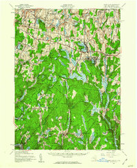
 1922 White Lake1922 Print · USGSSullivan County's lake-strewn highlands appear here in the early twenties, showing a landscape defined by small mountain hamlets and rural school districts. Genealogists can trace family names through landmarks like Stewart Cemetery, Bauer's Mill, and Mount Hope School.6 unique versions available
 - 1942 Map of White Lake, 1957 Print
 1942 White Lake1957 Print · USGSSullivan County’s landscape of ponds and mountain ridges is detailed here in the early 1940s as the area’s agricultural roots met a growing resort era. Researchers can trace the Newburgh And Cochecton Turnpike past the Stewart Cem and vanished local schools like Birch Ridge Sch.
 - 1942 Map of Port Jervis North, 1958 Print
 1942 Port Jervis North1958 Print · USGSThe tri-state border region near Port Jervis is shown here during the early war years, when the local economy centered on the river and heavy rail. Genealogists can trace family footprints near Sparrow Bush, Millrift, and several rural schoolhouses like Huguenot Sch No 2.2 unique versions available
 - 1942 Map of Otisville, 1959 Print
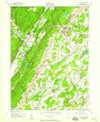 1942 Otisville1959 Print · USGSWestern Orange County during the early 1940s shows a landscape shaped by mountain ridges and the intersecting lines of the Erie RR and the New York Ontario and Western RR. Genealogists can locate family landmarks such as Mount Hope Cem or the local Godeffroy Sch.
 - 1943 Map of Port Jervis North
 1943 Port Jervis North1943 Print · USGSThe Delaware River valley north of Port Jervis appears here in the early 1940s, showing a landscape defined by mountain ridges and river industry. Genealogists can locate family landmarks like Eddys Farm or trace the early footprint of the Huguenot Airport and the Deerpark Brewery.
 - 1943 Map of Otisville
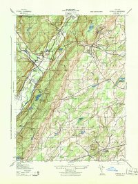 1943 Otisville1943 Print · USGSOrange and Sullivan Counties are shown in the 1940s as a hub of rail infrastructure and public health institutions. Researchers can trace the legacy of the N Y City Municipal Sanatorium, the Erie RR corridor, and local landmarks like Mount Hope Cemetery.
 - 1943 Map of White Lake, 1960 Print
 1943 White Lake1960 Print · USGSThe Sullivan County uplands appear in the mid-1940s as a landscape of rural schoolhouses and mountain resorts. Genealogists can trace family roots through sites like the Dutch Settlement, Tylertown Sch, and Beaver Brook Corners.2 unique versions available
 - 1943 Map of Monticello, 1961 Print
 1943 Monticello1961 Print · USGSSullivan County's resort and rail corridor comes into focus in the 1940s, highlighting the area's transition into a premier vacation destination. Local historians can trace the paths of the New York Ontario and Western RR and find specific seasonal hubs like Luzon Sta or the private Merriewold Park.3 unique versions available
 - 1943 Map of Monticello, 1964 Print
 1943 Monticello1964 Print · USGSSullivan County in the early 1940s is shown at a peak of its rural development before mid-century modernization changed the landscape. Genealogists and researchers can trace local roots through numerous district schools like the Bushville School and family landmarks such as the Stewart Cem or the industrial Dye Works.
 - 1944 Map of Milford
 1944 Milford1944 Print · USGSThe tri-state Delaware River valley was a network of river-bound hamlets and upland schools during the 1940s. Genealogists and local historians can trace family locations through named sites like Dark Swamp Sch, Mongaup Sta, and Quicktown.
 - 1944 Map of White Lake
 1944 White Lake1944 Print · USGSSullivan County was a landscape of small schools and highland waters in the mid-1940s. Genealogists and historians can trace the old road to Dutch Settlement or locate Neweiden Church and the Pintler Cem near the shores of White Lake.
 - 1944 Map of Monticello
 1944 Monticello1944 Print · USGSSullivan County in the 1940s is a landscape of mountain resorts and essential rail corridors during the height of the area's growth. Trace the rail-dependent growth of Monticello or find old family connections in settlements like Mountaindale and Hurleyville.
 - 1950 Map of Scranton, 1952 Print
 1950 Scranton1952 Print · USGSMid-century Northeast Pennsylvania and the Hudson Valley come alive in this survey of the tri-state region. Genealogists and historians can trace the dense rail networks of the Erie RR and DL&W RR between industrial hubs like Scranton and Wilkes-Barre.
 - 1953 Map of Scranton
 1953 Scranton1953 Print · USGSNortheastern Pennsylvania and the Catskills are shown in great detail during the early fifties, a time when rail lines and river valleys dictated the region's growth. Genealogists and historians can trace the industrial hearts of Scranton and Wilkes-Barre or locate remote landmarks like High Point and Lake Wallenpaupack.
 - 1959 Map of Scranton
 1959 Scranton1959 Print · USGSThe northern coalfields and the Hudson Valley meet in this mid-century survey of the Pennsylvania and New York borderlands. Genealogists and historians can trace the intricate rail networks of the Erie Railroad and the vast waters of Lake Wallenpaupack.2 unique versions available
 - 1962 Map of Scranton, 1977 Print
 1962 Scranton1977 Print · USGSThe industrial heart of eastern Pennsylvania and the New York Catskills are captured here in the early sixties. Genealogists and historians can trace the dense valley settlements from Scranton to Wilkes-Barre and the rail lines of the Erie Lackawanna Railroad.2 unique versions available
 - 1965 Map of Scranton
 1965 Scranton1965 Print · USGSThe tri-state highlands of Pennsylvania, New York, and New Jersey come alive in the mid-sixties as industry and recreation converge. Trace the intricate rail lines of the Erie Lackawanna RR or locate landmarks like the U S Military Academy.2 unique versions available
 - 1965 Map of Pond Eddy, 1967 Print
 1965 Pond Eddy1967 Print · USGSThe Delaware River gorge and the ERIE-LACKAWANNA rail line dominate this mid-sixties border landscape between New York and Pennsylvania. Genealogists and hikers can trace old routes near Pond Eddy, find the Sacred Heart Ch, or explore the deep woods of State Game Lands No 209.5 unique versions available
 - 1966 Map of Hartwood, 1967 Print
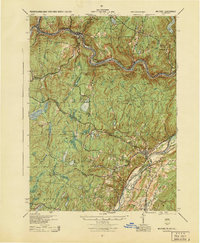
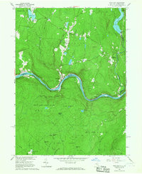
 1966 Hartwood1967 Print · USGSForestburg and the Neversink River valley are shown in the mid-1960s as a landscape of wooded hills and private sporting clubs. Genealogists and local historians can trace the foundations of Oakland Valley, locate St Thomas Cem, or follow the Old Railroad Grade near Philwold.2 unique versions available
Showing maps 1-25 of 65
Top cities near Forestburgh
- Warwick historical maps
- Wallkill historical maps
- Thompson historical maps
- Fallsburg historical maps
- Wawarsing historical maps
- Mamakating historical maps
See more
Top neighborhoods of Forestburgh
- Merriewold Club historical maps
- Philwold historical maps
- Squirrels Corners historical maps
- Forestburg historical maps
- Hartwood Club historical maps
- Oakland Valley historical maps
See more
Frequently asked questions
- What are the different types of historical maps available for Forestburgh?
- What is the oldest map of Forestburgh?
- Where can I purchase historical maps of Forestburgh for my home or office?
- Where can I download high-res historical maps of Forestburgh?
- Are there historical topographic maps available for Forestburgh?
- Is there historical aerial imagery available for Forestburgh?
- Where are historical maps of Forestburgh sourced from?