1900-1909 Maps of Tioga County, New York
Explore 8 historic maps of Tioga County from 1900-1909. These maps offer a rare glimpse into what life looked like during the 1900s — showing old roads, neighborhoods, homes, and landmarks that have changed or disappeared over time.
Whether you're researching your family's past, planning a metal detecting trip, or studying how Tioga County's landscape evolved across the 1900s, these high-resolution maps are a powerful tool for exploring the history of this region.
- Focus on a specific era: All maps on this page are from the 1900s, giving you a focused view of this time period.
- See what’s changed: Compare century-old streets, trails, and buildings to today's modern landscape using overlays and satellite layers.
- Research with precision: Use these maps for genealogy, historical research, land use analysis, or educational projects.
- View, download, or print: Maps are fully viewable online in high resolution, and can be downloaded or printed for your own records.
Start exploring Tioga County's history through authentic maps from the 1900s. This is your window into the past.
Tioga County, NY maps
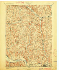
(8)- 1900 Map of Dryden
 1900 Dryden1900 Print · USGSThe Finger Lakes region comes to life in the late nineteenth century as the rail networks of the Lehigh Valley RR and the CAYUGA DIVISION expand through the valleys. Genealogists can trace family roots through the hill settlements of Caroline Center, South Danby, and the early grounds of Cornell University.9 unique versions available
 - 1901 Map of Apalachin
 1901 Apalachin1901 Print · USGSThe Susquehanna River valley at the start of the twentieth century shows the rise of industrial towns and old riverside settlements. Researchers can trace early rail corridors like the Auburn Div or locate family homesteads near Waite Settlement and Flemingsville.
 - 1902 Map of Waverly
 1902 Waverly1902 Print · USGSThe Chemung River valley and the Pennsylvania borderlands come alive in this turn-of-the-century survey of Tioga and Chemung counties. Genealogists and rail historians can trace defunct stations and crossroads like Van Etten Junction, Owens Mills, and the village of Wellsburg.7 unique versions available
 - 1903 Map of Owego
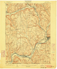 1903 Owego1903 Print · USGSTioga County at the turn of the century is defined by its busy river landings and a dense web of competing railroads. Genealogists and historians can trace old property sites near Deans Tannery, Halsey Valley, and the rural crossroads of Straits Corners.6 unique versions available
 - 1903 Map of Harford
 1903 Harford1903 Print · USGSThe Southern Tier of New York at the turn of the century reveals a landscape defined by deep valleys and the competing paths of the Lehigh Valley and Lackawanna railroads. Genealogists can trace early homesteads and hamlets like Harford Mills, Nanticoke, and Hunts Corners.5 unique versions available
 - 1904 Map of Apalachin
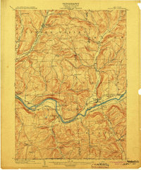 1904 Apalachin1904 Print · USGSThe Susquehanna River valley at the turn of the century shows a landscape defined by heavy rail and early industry. Genealogists can trace family names and small upland hamlets like Waite Settlement, Oakley Cors, and Newark Valley before the modern highway era.8 unique versions available
 - 1905 Map of Watkins Glen
 1905 Watkins Glen1905 Print · USGSThe Finger Lakes and Southern Tier regions are captured at the start of the century, showing a landscape defined by deep glens and heavy rail. Genealogists and historians can trace the paths of the Northern Central RR through Watkins or locate family sites near Burdett and Horseheads.4 unique versions available
 - 1906 Map of Catatonk
 1906 Catatonk1906 Print · USGSThe Southern Tier and Finger Lakes foothills are shown here at the peak of the rail era, before the expansion of modern highways. Genealogists can locate family lands near Slaterville Springs, trace the Lehigh Valley RR, or find early sites like White Church.
End of results
Showing maps 1-8 of 8
Top cities of Tioga County
- Owego historical maps
- Barton historical maps
- Candor historical maps
- Tioga historical maps
- Newark Valley historical maps
- Spencer historical maps
See more
Frequently asked questions
- What are the different types of historical maps available for Tioga County?
- What is the oldest map of Tioga County?
- Where can I purchase historical maps of Tioga County for my home or office?
- Where can I download high-res historical maps of Tioga County?
- Are there historical topographic maps available for Tioga County?
- Is there historical aerial imagery available for Tioga County?
- Where are historical maps of Tioga County sourced from?