1900s (20th Century) Maps of Mapledale, Hardenburgh
Explore 9 historic maps of Mapledale from the 1900s (20th Century). These maps offer a rare glimpse into what life looked like during the 1900s — showing old roads, neighborhoods, homes, and landmarks that have changed or disappeared over time.
Whether you're researching your family's past, planning a metal detecting trip, or studying how Mapledale's landscape evolved across the 1900s, these high-resolution maps are a powerful tool for exploring the history of this region.
- Focus on a specific era: All maps on this page are from the 1900s, giving you a focused view of this time period.
- See what’s changed: Compare century-old streets, trails, and buildings to today's modern landscape using overlays and satellite layers.
- Research with precision: Use these maps for genealogy, historical research, land use analysis, or educational projects.
- View, download, or print: Maps are fully viewable online in high resolution, and can be downloaded or printed for your own records.
Start exploring Mapledale's history through authentic maps from the 1900s. This is your window into the past.
Mapledale, Hardenburgh maps
(9)- 1901 Map of Margaretville, 1961 Print
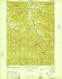
 1901 Margaretville1961 Print · USGSThe Catskills at the turn of the century are defined here by river-valley settlements and the Ulster and Delaware railroad line. Genealogists and historians can trace family-named hollows and vanished settlements like Grant Mills, Arena, and Griffin Corners.
 - 1904 Map of Margaretville
 1904 Margaretville1904 Print · USGSThe Catskills' high-valley communities thrive along the Ulster and Delaware RR at the turn of the century. Trace old family farmsteads and rural mountain hamlets like Arena, New Kingston, and Griffin Corners as they appeared in 1904.7 unique versions available
 - 1945 Map of Seager
 1945 Seager1945 Print · USGSThe high peaks and deep valleys of the Catskills appear here at the end of World War II, showing a landscape defined by forest and stream. Genealogists and hikers can trace old landmarks like School No 4, the Baker Cem, and the Balsam Lookout Tower.5 unique versions available
 - 1946 Map of Seager
 1946 Seager1946 Print · USGSThe high Catskills of the mid-1940s are meticulously detailed in this survey of the hollows and peaks along the Ulster and Delaware county line. Genealogists and researchers can locate remote landmarks like Lake Hill Cem, School No 4, and the Balsam Lookout Tower.
 - 1948 Map of Binghamton, 1980 Print
 1948 Binghamton1980 Print · USGSCentral New York and the Southern Tier thrive in the late 1940s as a hub of rail traffic and mountain industry. Researchers can trace historic transit lines like the Erie Railroad through Binghamton or find old valley settlements near Oneonta and Delhi.
 - 1950 Map of Binghamton
 1950 Binghamton1950 Print · USGSBinghamton and the surrounding Southern Tier are shown in the mid-century era, highlighting the intricate rail and river networks that drove local industry. Researchers can trace the path of the Erie Railroad and locate landmarks from Otsego Lake to Sidney Mountain.2 unique versions available
 - 1958 Map of Binghamton
 1958 Binghamton1958 Print · USGSCentral New York in the late fifties was a network of manufacturing cities and river valleys connected by vital rail lines. Genealogists and historians can trace family roots in Oneonta, Norwich, and Cooperstown or locate long-standing farms along Schoharie Creek.
 - 1963 Map of Binghamton
 1963 Binghamton1963 Print · USGSThe Southern Tier and Catskill peaks are shown in the early sixties as new reservoirs reshaped the valleys. Trace historic rail corridors like the Erie Lackawanna RR and explore lakeside settlements such as Cooperstown and Oneonta.
 - 1986 Map of Pepacton Reservoir
 1986 Pepacton Reservoir1986 Print · USGSThe Catskills in the mid-eighties show a landscape shaped by the Pepacton Reservoir and protected wilderness. Local historians can trace mountain rail corridors like the Delaware & Ulster RR and locate high-elevation landmarks from Slide Mountain to Hunter Mountain.2 unique versions available
End of results
Showing maps 1-9 of 9
Top cities near Mapledale
- Liberty historical maps
- Rochester historical maps
- Olive historical maps
- Neversink historical maps
- Middletown historical maps
- Rockland historical maps
See more
Frequently asked questions
- What are the different types of historical maps available for Mapledale?
- What is the oldest map of Mapledale?
- Where can I purchase historical maps of Mapledale for my home or office?
- Where can I download high-res historical maps of Mapledale?
- Are there historical topographic maps available for Mapledale?
- Is there historical aerial imagery available for Mapledale?
- Where are historical maps of Mapledale sourced from?