1940s Maps of Marlboro, Marlborough
Explore 6 historic maps of Marlboro from the 1940s. These maps offer a rare glimpse into what life looked like during the 1940s — showing old roads, neighborhoods, homes, and landmarks that have changed or disappeared over time.
Whether you're researching your family's past, planning a metal detecting trip, or studying how Marlboro's landscape evolved across the 1940s, these high-resolution maps are a powerful tool for exploring the history of this region.
- Focus on a specific era: All maps on this page are from the 1940s, giving you a focused view of this time period.
- See what’s changed: Compare century-old streets, trails, and buildings to today's modern landscape using overlays and satellite layers.
- Research with precision: Use these maps for genealogy, historical research, land use analysis, or educational projects.
- View, download, or print: Maps are fully viewable online in high resolution, and can be downloaded or printed for your own records.
Start exploring Marlboro's history through authentic maps from the 1940s. This is your window into the past.
Marlboro, Marlborough maps
(6)- 1943 Map of Poughkeepsie
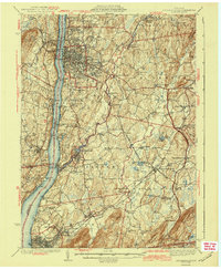 1943 Poughkeepsie1943 Print · USGSThe mid-Hudson valley is captured here in the years during the Second World War, showing the busy corridor between Poughkeepsie and Beacon. Researchers can trace old institutional lands like Vassar College or locate vanished rural schools such as Swede Sch and Devine Sch.3 unique versions available
 - 1946 Map of Newburgh, 1964 Print
 1946 Newburgh1964 Print · USGSMid-Hudson Valley life in the mid-forties is captured here, showing the region as it transitioned from a rural agricultural economy to a postwar industrial hub. Genealogists and local historians can locate dozens of small schools and cemeteries, from the New Paltz Cemetery to the Montgomery Worsted Mills.
 - 1947 Map of Wappinger Falls
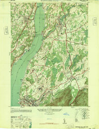 1947 Wappinger Falls1947 Print · USGSThe Hudson River corridor in the late 1940s is shown here at its post-war industrial height, from the busy streets of Beacon to the mills of Wappingers Falls. Researchers can trace the legacy of major institutions like Matteawan State Hospital or locate local landmarks such as Danskammer Light and Cedar Cliff School.2 unique versions available
 - 1947 Map of Newburgh North
 1947 Newburgh North1947 Print · USGSMid-century Orange County comes alive along the western Hudson at a time when river transport and rural schoolhouses defined the landscape. Genealogists can trace family names through the Plattekill School and Savilton, or locate landmarks like Pine Point Casino.
 - 1947 Map of Hartford, 1955 Print
 1947 Hartford1955 Print · USGSSouthern New England and the Hudson Valley are shown in detail during the post-war expansion era. Genealogists and researchers can trace local landmarks from the State Capitol and Yale University to the Stratford Lighthouse and Woodlawn Cem.2 unique versions available
 - 1948 Map of Hartford
 1948 Hartford1948 Print · USGSSouthern New England is captured here in the late 1940s, showcasing a landscape of thriving industrial cities and developing parkways. Genealogists and historians can trace the rail networks of the New York New Haven and Hartford RR or locate coastal defense sites like Fort Terry and Camp Shanks.2 unique versions available
End of results
Showing maps 1-6 of 6
Top cities near Marlboro
- Poughkeepsie historical maps
- Carmel historical maps
- Newburgh historical maps
- Poughkeepsie historical maps
- East Fishkill historical maps
- Newburgh historical maps
See more
Frequently asked questions
- What are the different types of historical maps available for Marlboro?
- What is the oldest map of Marlboro?
- Where can I purchase historical maps of Marlboro for my home or office?
- Where can I download high-res historical maps of Marlboro?
- Are there historical topographic maps available for Marlboro?
- Is there historical aerial imagery available for Marlboro?
- Where are historical maps of Marlboro sourced from?