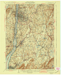
1943 Map of Poughkeepsie
USGS Topo · Published 1943About this map
Poughkeepsie serves as the focal point of this mid-century survey, anchored by the Mid-Hudson Bridge spanning the Hudson River to Highland. The landscape reveals a sophisticated network of 1940s infrastructure and institutional geography, with major sites like Vassar College, St Andrews on the Hudson, and the Hudson River Hospital prominently mapped. To the south and east, the industrial and residential character of the river valley is defined by Wappingers Falls and Beacon, while rural schoolhouses like Lockwood Sch and Sloatmore Sch dot the surrounding uplands.
Find a feature on this map
104 named features on this map. Tap any name to fly to it.
Don’t see what you’re looking for? This feature index may not catch every label — zoom into the map to look around manually.
Map Details
Editions of this 1943 Poughkeepsie Map
3 editions found
Other maps of this area

1892 · West Point
USGS Topo · 1:62,500

1892 · Carmel
USGS Topo · 1:62,500

1893 · Carmel
USGS Topo · 1:62,500

1893 · Clove
USGS Topo · 1:62,500

1893 · Poughkeepsie
USGS Topo · 1:62,500

1894 · West Point
USGS Topo · 1:62,500

1894 · Clove
USGS Topo · 1:62,500

1894 · Carmel
USGS Topo · 1:62,500

1894 · Poughkeepsie
USGS Topo · 1:62,500

1898 · Clove
USGS Topo · 1:62,500