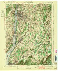
1943 Map of Poughkeepsie
USGS Topo · Published 1943About this map
Poughkeepsie and the surrounding mid-Hudson valley reflect an era of significant institutional and industrial growth during the mid-1930s. The city is a hub of connectivity, featuring the Mid-Hudson Bridge spanning the Hudson River and a dense network of rail lines including the New York Central RR and the Central New England RR. Notable centers of learning and care, such as Vassar College and the sprawling grounds of the Hudson River Hospital, dominate the eastern plateau, while the riverfront supports industrial operations near Clinton Point Stoneco PO and New Hamburg. In the surrounding townships of Lagrange and Wappinger, the landscape is dotted with numerous district schools like Maple Place Sch and Lockwood Sch, alongside long-established crossroads such as Manchester Bridge and Hopewell Junction. This geography captures the transition between the urban density of the river towns and the agricultural valleys of Sprout Creek and Fishkill Creek.
Find a feature on this map
107 named features on this map. Tap any name to fly to it.
Don’t see what you’re looking for? This feature index may not catch every label — zoom into the map to look around manually.
Map Details
Editions of this 1943 Poughkeepsie Map
3 editions found
Other maps of this area

1892 · West Point
USGS Topo · 1:62,500

1892 · Carmel
USGS Topo · 1:62,500

1893 · Carmel
USGS Topo · 1:62,500

1893 · Clove
USGS Topo · 1:62,500

1893 · Poughkeepsie
USGS Topo · 1:62,500

1894 · West Point
USGS Topo · 1:62,500

1894 · Clove
USGS Topo · 1:62,500

1894 · Carmel
USGS Topo · 1:62,500

1894 · Poughkeepsie
USGS Topo · 1:62,500

1898 · Clove
USGS Topo · 1:62,500