1960s Maps of Ulster, New York
Explore 11 historic maps of Ulster from the 1960s. These maps offer a rare glimpse into what life looked like during the 1960s — showing old roads, neighborhoods, homes, and landmarks that have changed or disappeared over time.
Whether you're researching your family's past, planning a metal detecting trip, or studying how Ulster's landscape evolved across the 1960s, these high-resolution maps are a powerful tool for exploring the history of this region.
- Focus on a specific era: All maps on this page are from the 1960s, giving you a focused view of this time period.
- See what’s changed: Compare century-old streets, trails, and buildings to today's modern landscape using overlays and satellite layers.
- Research with precision: Use these maps for genealogy, historical research, land use analysis, or educational projects.
- View, download, or print: Maps are fully viewable online in high resolution, and can be downloaded or printed for your own records.
Start exploring Ulster's history through authentic maps from the 1960s. This is your window into the past.
Ulster, NY maps
(11)- 1961 Map of Hartford
 1961 Hartford1961 Print · USGSSouthern New England and the Hudson Valley are shown here in the mid-fifties, capturing a landscape of booming coastal cities and interior hill towns. Researchers can trace the legacy of the New York New Haven and Hartford rail corridor and find strategic sites like Camp Shanks and Fort Michie.
 - 1962 Map of Albany
 1962 Albany1962 Print · USGSThe Hudson and Connecticut River valleys meet the Green Mountains and Berkshires in this mid-century overview of the Northeast. Genealogists and historians can trace the industrial hearts of Albany and Springfield or locate features like Quabbin Reservoir and Westover Air Force Base.
 - 1962 Map of Hartford, 1971 Print
 1962 Hartford1971 Print · USGSSouthern New England and the Hudson Valley are shown in the early sixties, as suburban growth reached into the foothills. Trace the path of the New York New Haven & Hartford RR and find landmarks like Camp Nathan Hale and Gillette Castle State Park.3 unique versions available
 - 1962 Map of Scranton, 1977 Print
 1962 Scranton1977 Print · USGSThe industrial heart of eastern Pennsylvania and the New York Catskills are captured here in the early sixties. Genealogists and historians can trace the dense valley settlements from Scranton to Wilkes-Barre and the rail lines of the Erie Lackawanna Railroad.2 unique versions available
 - 1963 Map of Binghamton
 1963 Binghamton1963 Print · USGSThe Southern Tier and Catskill peaks are shown in the early sixties as new reservoirs reshaped the valleys. Trace historic rail corridors like the Erie Lackawanna RR and explore lakeside settlements such as Cooperstown and Oneonta.
 - 1963 Map of Kingston East, 1965 Print
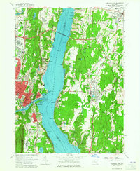 1963 Kingston East1965 Print · USGSMid-century life along the Hudson River is captured here just as the Kingston-Rhinecliff Bridge transformed local travel. Genealogists can trace family names at St Marys Cemetery or locate schools like the Cardinal Farley Military Academy and Wygant Sch.5 unique versions available
 - 1963 Map of Saugerties, 1965 Print
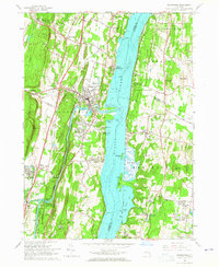 1963 Saugerties1965 Print · USGSThe Hudson River waterfront near Saugerties is captured here in the early 1960s, showing a landscape of historic estates and river-oriented industry. Genealogists can trace family sites in Malden-on-Hudson, locate the Birthplace of Robert Livingston, or find St Marys Ch.5 unique versions available
 - 1964 Map of Rosendale, 1966 Print
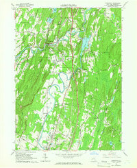 1964 Rosendale1966 Print · USGSMid-century Ulster County is captured here at the junction of the Rondout Creek and Wallkill River. Researchers can trace old industrial sites like the Binnewater quarries, find the historic Covered Bridge, or locate family sites at St Peters Cem.3 unique versions available
 - 1964 Map of Kingston West, 1966 Print
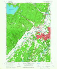 1964 Kingston West1966 Print · USGSMid-century Ulster County shows a landscape defined by the Esopus valley and the growing city of KINGSTON. Genealogists and historians can trace family plots in Old Dutch Cem or locate former schoolhouse sites like West Hurley District Sch No 8.4 unique versions available
 - 1965 Map of Scranton
 1965 Scranton1965 Print · USGSThe tri-state highlands of Pennsylvania, New York, and New Jersey come alive in the mid-sixties as industry and recreation converge. Trace the intricate rail lines of the Erie Lackawanna RR or locate landmarks like the U S Military Academy.2 unique versions available
 - 1965 Map of Hartford
 1965 Hartford1965 Print · USGSSouthern New England and the Hudson Valley are shown here during the mid-sixties expansion of the Interstate era. Trace the path of the New York New Haven & Hartford RR or locate historic landmarks like West Point Military Reservation and the Merritt Parkway.2 unique versions available
End of results
Showing maps 1-11 of 11
Top cities near Ulster
- Poughkeepsie historical maps
- Kingston historical maps
- Hyde Park historical maps
- Saugerties historical maps
- La Grange historical maps
- New Paltz historical maps
See more
Top neighborhoods of Ulster
- Ulster Landing historical maps
- Glenerie Lake Park historical maps
- Eddyville historical maps
- Lincoln Park historical maps
- Lake Katrine historical maps
- Ruby historical maps
See more
Frequently asked questions
- What are the different types of historical maps available for Ulster?
- What is the oldest map of Ulster?
- Where can I purchase historical maps of Ulster for my home or office?
- Where can I download high-res historical maps of Ulster?
- Are there historical topographic maps available for Ulster?
- Is there historical aerial imagery available for Ulster?
- Where are historical maps of Ulster sourced from?