1940s Maps of Wawarsing, New York
Explore 13 historic maps of Wawarsing from the 1940s. These maps offer a rare glimpse into what life looked like during the 1940s — showing old roads, neighborhoods, homes, and landmarks that have changed or disappeared over time.
Whether you're researching your family's past, planning a metal detecting trip, or studying how Wawarsing's landscape evolved across the 1940s, these high-resolution maps are a powerful tool for exploring the history of this region.
- Focus on a specific era: All maps on this page are from the 1940s, giving you a focused view of this time period.
- See what’s changed: Compare century-old streets, trails, and buildings to today's modern landscape using overlays and satellite layers.
- Research with precision: Use these maps for genealogy, historical research, land use analysis, or educational projects.
- View, download, or print: Maps are fully viewable online in high resolution, and can be downloaded or printed for your own records.
Start exploring Wawarsing's history through authentic maps from the 1940s. This is your window into the past.
Wawarsing, NY maps
(13)- 1942 Map of Neversink, 1958 Print
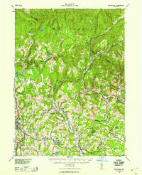 1942 Neversink1958 Print · USGSThe Catskills come alive in this wartime survey, showing the deep river valleys and high peaks of Sullivan and Ulster counties. Trace old rail lines like the NYO AND W RR or find family landmarks in hamlets such as Claryville, Loch Sheldrake, and Grahamsville.2 unique versions available
 - 1942 Map of Lackawack, 1959 Print
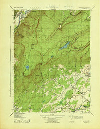
 1942 Lackawack1959 Print · USGSUlster County's Rondout Valley is captured here during the 1940s, just as reservoir construction began to transform the local landscape forever. Genealogists and historians can trace the final years of valley communities like Montela and Lackawack, alongside family-named landmarks such as Furman Cem and Yagerville Sch.
 - 1942 Map of Kerhonkson, 1959 Print
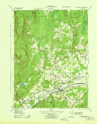
 1942 Kerhonkson1959 Print · USGSUlster County's transport and settlement patterns are frozen in time during the early 1940s. Genealogists and historians can trace the New York Ontario and Western line, the old Rondout and Western Canal, and local landmarks like Soccanissing Sch.
 - 1942 Map of Ellenville, 1959 Print
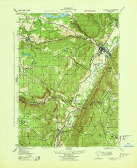
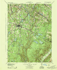
 1942 Ellenville1959 Print · USGSThe valleys surrounding Ellenville and the Shawangunk Mountains are seen here at a mid-century crossroads of transport history. Genealogists can locate family-named landmarks like Poplar Grove Cem and several rural schoolhouses, including Sandburg Rend Sch and Greenwood Sch.2 unique versions available
 - 1943 Map of Peekamoose Mountain
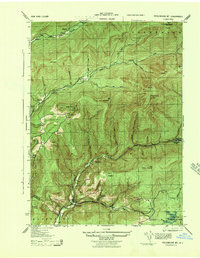 1943 Peekamoose Mountain1943 Print · USGSIn the heart of the Catskill Mountains during the mid-forties, this area remains a landscape of high summits and isolated valley settlements. Researchers can trace remote family homesteads and local institutions like the Greenville School, Richmond Camp, and the Slide Mountain Fire Tower.3 unique versions available
 - 1943 Map of Lackawack
 1943 Lackawack1943 Print · USGSThe Ulster County uplands are captured here during a period of massive hydraulic engineering. Genealogists and local historians can trace family farmsteads and rural schools like Stangle Hill School near the massive footprint of the Merriman Dam.
 - 1943 Map of Napanoch
 1943 Napanoch1943 Print · USGSThe Shawangunk Mountains and the valley of the Rondout Creek are captured here in the early 1940s. Genealogists and historians can trace family properties like V Mahon and H Hall or locate rural landmarks such as Crawford Church and the Union District School.
 - 1943 Map of Kerhonkson
 1943 Kerhonkson1943 Print · USGSMid-century Ulster County comes to life through this survey of the Rondout Valley and the Ontario and Western rail corridor. Genealogists can trace family holdings and local schools like Wawarsing School, Cherrytown, and the Frank Utter Colony Farm.
 - 1943 Map of Ellenville
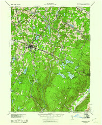
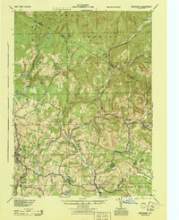
 1943 Ellenville1943 Print · USGSThe Shawangunk valley corridor during the war years shows a landscape defined by the Delaware and Hudson Canal and the O&W railroad. Trace local roots at Fantine Cemetery or find historic sites like the Pepsi Cola Bottling Co and Greenwood School.
 - 1943 Map of Monticello, 1961 Print
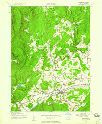
 1943 Monticello1961 Print · USGSSullivan County's resort and rail corridor comes into focus in the 1940s, highlighting the area's transition into a premier vacation destination. Local historians can trace the paths of the New York Ontario and Western RR and find specific seasonal hubs like Luzon Sta or the private Merriewold Park.3 unique versions available
 - 1943 Map of Monticello, 1964 Print
 1943 Monticello1964 Print · USGSSullivan County in the early 1940s is shown at a peak of its rural development before mid-century modernization changed the landscape. Genealogists and researchers can trace local roots through numerous district schools like the Bushville School and family landmarks such as the Stewart Cem or the industrial Dye Works.
 - 1944 Map of Monticello
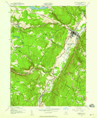
 1944 Monticello1944 Print · USGSSullivan County in the 1940s is a landscape of mountain resorts and essential rail corridors during the height of the area's growth. Trace the rail-dependent growth of Monticello or find old family connections in settlements like Mountaindale and Hurleyville.
 - 1944 Map of Neversink
 1944 Neversink1944 Print · USGSThe Catskills of the mid-1940s come alive in this survey of the river valleys before later reservoir development. Genealogists and historians can trace old homesteads near Willowemoc, follow the NYO AND W RR through Ferndale, and locate Union Ch and Divine Corners.
End of results
Showing maps 1-13 of 13
Top cities near Wawarsing
- Wallkill historical maps
- Montgomery historical maps
- Thompson historical maps
- Fallsburg historical maps
- Shawangunk historical maps
- Mamakating historical maps
See more
Top neighborhoods of Wawarsing
- Spring Glen historical maps
- Dairyland historical maps
- Lackawack historical maps
- Port Ben historical maps
- Ulster Heights historical maps
- Brownville historical maps
See more
Frequently asked questions
- What are the different types of historical maps available for Wawarsing?
- What is the oldest map of Wawarsing?
- Where can I purchase historical maps of Wawarsing for my home or office?
- Where can I download high-res historical maps of Wawarsing?
- Are there historical topographic maps available for Wawarsing?
- Is there historical aerial imagery available for Wawarsing?
- Where are historical maps of Wawarsing sourced from?