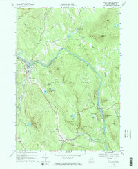
1960s Maps of Chester, New York
Explore 9 historic maps of Chester from the 1960s. These maps offer a rare glimpse into what life looked like during the 1960s — showing old roads, neighborhoods, homes, and landmarks that have changed or disappeared over time.
Whether you're researching your family's past, planning a metal detecting trip, or studying how Chester's landscape evolved across the 1960s, these high-resolution maps are a powerful tool for exploring the history of this region.
- Focus on a specific era: All maps on this page are from the 1960s, giving you a focused view of this time period.
- See what’s changed: Compare century-old streets, trails, and buildings to today's modern landscape using overlays and satellite layers.
- Research with precision: Use these maps for genealogy, historical research, land use analysis, or educational projects.
- View, download, or print: Maps are fully viewable online in high resolution, and can be downloaded or printed for your own records.
Start exploring Chester's history through authentic maps from the 1960s. This is your window into the past.
Chester, NY maps
(9)- 1962 Map of Utica
 1962 Utica1962 Print · USGSCentral New York and the Adirondack wilderness are captured here during the mid-century era of highway and industrial expansion. Genealogists and historians can trace the development of the New York State Thruway and local rail lines connecting Utica, Rome, and Gloversville.3 unique versions available
 - 1964 Map of Glens Falls
 1964 Glens Falls1964 Print · USGSThe tri-state borderlands of New York, Vermont, and New Hampshire appear here in the mid-1960s. Researchers can trace the rail routes of the Rutland RR and find historic sites like Ticonderoga and Saratoga National Historical Park.
 - 1964 Map of Utica
 1964 Utica1964 Print · USGSCentral New York and the high wilderness of the Adirondacks are captured here during the post-war era of infrastructure expansion. Researchers can trace the development of the New York State Thruway alongside historic corridors like the Oneida Lake (Barge Canal Route) and the N. Y. Central railroad.
 - 1966 Map of Brant Lake, 1969 Print
 1966 Brant Lake1969 Print · USGSWarren County’s mountainous interior is shown in detail during the mid-sixties, centered on the long reach of Brant Lake. Local historians can trace old routes like Palisades Road and find landmarks such as the Cem near the Bolton township line.
 - 1967 Map of Utica
 1967 Utica1967 Print · USGSCentral New York's industrial Mohawk Valley meets the Adirondack wilderness in the 1960s, showing the region's transition from manufacturing hubs to state-managed parklands. Trace historic settlements and sites like Griffiss Air Force Base, Colgate University, and the Lyons Falls Paper Mill.
 - 1968 Map of Chestertown, 1970 Print
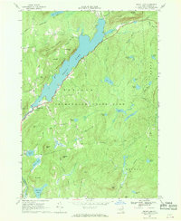
 1968 Chestertown1970 Print · USGSThe Adirondack landscape of the late sixties comes to life here, from the resort shores of Loon Lake to the river junction at Starbuckville. Local researchers can trace family landmarks like Underwood Cem, the old Drive-in Theater, and the grounds of the Central Sch.2 unique versions available
 - 1968 Map of Johnsburg, 1970 Print
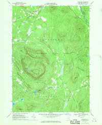 1968 Johnsburg1970 Print · USGSIn the heart of the southeastern Adirondacks during the late sixties, this map shows a landscape of timbered peaks and high ponds. Researchers can find old backcountry routes like Mud Pond Trail and follow the flow of the Hudson River past Johnsburg.3 unique versions available
 - 1968 Map of The Glen, 1970 Print
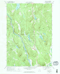 1968 The Glen1970 Print · USGSThe upper Hudson River valley comes into focus in the late sixties, showing the vital link between the Delaware and Hudson railroad and the river. Genealogists and hikers can trace old routes like Mansion Road past Darrowsville or locate family landmarks near The Glen and Friends Lake.
 - 1968 Map of North Creek, 1970 Print
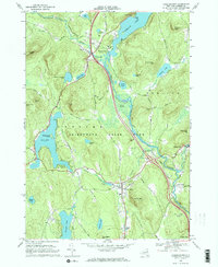
 1968 North Creek1970 Print · USGSWarren County’s river valleys and Adirondack peaks are shown here in the late sixties as the timber and rail era persisted. Researchers can locate family landmarks near North Creek, the river crossing at Riparius, or the Central Sch.2 unique versions available
End of results
Showing maps 1-9 of 9
Top cities near Chester
- Queensbury historical maps
- Warrensburg historical maps
- Lake George historical maps
- Johnsburg historical maps
- Bolton historical maps
- Schroon historical maps
See more
Top neighborhoods of Chester
- Darrowsville historical maps
- Starbuckville historical maps
- Riparius historical maps
- Igerna historical maps
- Chestertown historical maps
- Pottersville historical maps
Frequently asked questions
- What are the different types of historical maps available for Chester?
- What is the oldest map of Chester?
- Where can I purchase historical maps of Chester for my home or office?
- Where can I download high-res historical maps of Chester?
- Are there historical topographic maps available for Chester?
- Is there historical aerial imagery available for Chester?
- Where are historical maps of Chester sourced from?