1960s Maps of Lake George, New York
Explore 7 historic maps of Lake George from the 1960s. These maps offer a rare glimpse into what life looked like during the 1960s — showing old roads, neighborhoods, homes, and landmarks that have changed or disappeared over time.
Whether you're researching your family's past, planning a metal detecting trip, or studying how Lake George's landscape evolved across the 1960s, these high-resolution maps are a powerful tool for exploring the history of this region.
- Focus on a specific era: All maps on this page are from the 1960s, giving you a focused view of this time period.
- See what’s changed: Compare century-old streets, trails, and buildings to today's modern landscape using overlays and satellite layers.
- Research with precision: Use these maps for genealogy, historical research, land use analysis, or educational projects.
- View, download, or print: Maps are fully viewable online in high resolution, and can be downloaded or printed for your own records.
Start exploring Lake George's history through authentic maps from the 1960s. This is your window into the past.
Lake George, NY maps
(7)- 1964 Map of Glens Falls
 1964 Glens Falls1964 Print · USGSThe tri-state borderlands of New York, Vermont, and New Hampshire appear here in the mid-1960s. Researchers can trace the rail routes of the Rutland RR and find historic sites like Ticonderoga and Saratoga National Historical Park.
 - 1966 Map of Glens Falls, 1968 Print
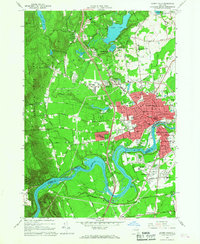 1966 Glens Falls1968 Print · USGSGlens Falls and its neighboring Hudson River riverfronts are captured in the mid-sixties as the Adirondack Northway reshaped the region's geography. Genealogists can locate family sites at the Friends Cem and St Marys Cem or trace the early development of West Glens Falls.
 - 1966 Map of Lake George, 1969 Print
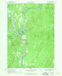
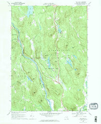
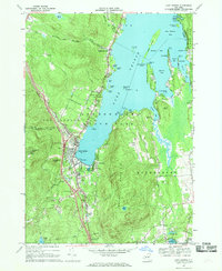 1966 Lake George1969 Print · USGSLake George enters a new era of accessibility in the mid-sixties as the Adirondack Northway connects with established mountain resorts. Researchers can trace historic sites like Fort William Henry alongside local landmarks such as the Stone Schoolhouse and Bloody Pond.3 unique versions available
 - 1966 Map of Warrensburg, 1969 Print
 1966 Warrensburg1969 Print · USGSWarrensburg and the Hudson River valley are shown here in the mid-sixties, capturing the area just as the Northway was reshaping local transit. Genealogists and hikers can trace old routes like Old Stage Road or locate landmarks such as the Fish Hatchery and Christ Community Ch.2 unique versions available
 - 1966 Map of Bolton Landing, 1969 Print
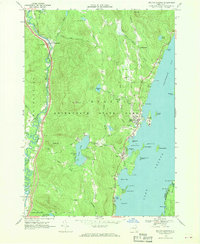 1966 Bolton Landing1969 Print · USGSLake George's western shoreline in the mid-sixties is captured here, showing the village of Bolton Landing as it balanced mountain heritage with lakeside development. Genealogists and historians can trace family sites at New Vermont Cem and Lamb Hill Cem or locate old crossings along the Schroon River.2 unique versions available
 - 1968 Map of Lake Luzerne, 1970 Print
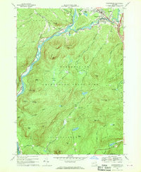
 1968 Lake Luzerne1970 Print · USGSThe upper Hudson River valley in the late sixties is shown here as the Delaware and Hudson railroad winds through the Adirondack foothills. Genealogists and hikers can locate the Old Methodist Cem, trace the roads near Danielstown, or explore the terrain around Lake Luzerne.3 unique versions available
 - 1968 Map of The Glen, 1970 Print
 1968 The Glen1970 Print · USGSThe upper Hudson River valley comes into focus in the late sixties, showing the vital link between the Delaware and Hudson railroad and the river. Genealogists and hikers can trace old routes like Mansion Road past Darrowsville or locate family landmarks near The Glen and Friends Lake.
End of results
Showing maps 1-7 of 7
Top cities near Lake George
- Queensbury historical maps
- Moreau historical maps
- Glens Falls historical maps
- Kingsbury historical maps
- Glens Falls North historical maps
- Hudson Falls historical maps
See more
Top neighborhoods of Lake George
- Diamond Point (hamlet) historical maps
- Crosbyside historical maps
- Rocks historical maps
- Lake George historical maps
Frequently asked questions
- What are the different types of historical maps available for Lake George?
- What is the oldest map of Lake George?
- Where can I purchase historical maps of Lake George for my home or office?
- Where can I download high-res historical maps of Lake George?
- Are there historical topographic maps available for Lake George?
- Is there historical aerial imagery available for Lake George?
- Where are historical maps of Lake George sourced from?