1960s Maps of Lake Luzerne, New York
Explore 8 historic maps of Lake Luzerne from the 1960s. These maps offer a rare glimpse into what life looked like during the 1960s — showing old roads, neighborhoods, homes, and landmarks that have changed or disappeared over time.
Whether you're researching your family's past, planning a metal detecting trip, or studying how Lake Luzerne's landscape evolved across the 1960s, these high-resolution maps are a powerful tool for exploring the history of this region.
- Focus on a specific era: All maps on this page are from the 1960s, giving you a focused view of this time period.
- See what’s changed: Compare century-old streets, trails, and buildings to today's modern landscape using overlays and satellite layers.
- Research with precision: Use these maps for genealogy, historical research, land use analysis, or educational projects.
- View, download, or print: Maps are fully viewable online in high resolution, and can be downloaded or printed for your own records.
Start exploring Lake Luzerne's history through authentic maps from the 1960s. This is your window into the past.
Lake Luzerne, NY maps
(8)- 1964 Map of Glens Falls
 1964 Glens Falls1964 Print · USGSThe tri-state borderlands of New York, Vermont, and New Hampshire appear here in the mid-1960s. Researchers can trace the rail routes of the Rutland RR and find historic sites like Ticonderoga and Saratoga National Historical Park.
 - 1966 Map of Glens Falls, 1968 Print
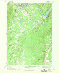
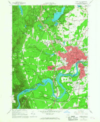 1966 Glens Falls1968 Print · USGSGlens Falls and its neighboring Hudson River riverfronts are captured in the mid-sixties as the Adirondack Northway reshaped the region's geography. Genealogists can locate family sites at the Friends Cem and St Marys Cem or trace the early development of West Glens Falls.
 - 1966 Map of Warrensburg, 1969 Print
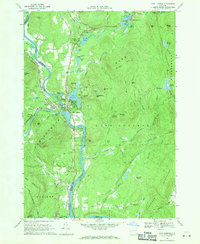
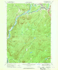 1966 Warrensburg1969 Print · USGSWarrensburg and the Hudson River valley are shown here in the mid-sixties, capturing the area just as the Northway was reshaping local transit. Genealogists and hikers can trace old routes like Old Stage Road or locate landmarks such as the Fish Hatchery and Christ Community Ch.2 unique versions available
 - 1966 Map of Conklingville, 1970 Print
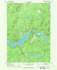 1966 Conklingville1970 Print · USGSSaratoga County was a landscape defined by water and timber in the mid-sixties, dominated by the massive Sacandaga Reservoir. Genealogists and historians can trace old mountain roads and family landmarks like Sandpit Cem, Hunt Lake, and the hamlet of Conklingville.2 unique versions available
 - 1968 Map of Gansevoort
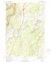 1968 Gansevoort1968 Print · USGSSaratoga County was undergoing significant change in the late sixties as the interstate era reshaped the rural landscape near the Hudson River. Genealogists and local historians can trace family-named crossroads like Dimmick Corners and Clarks Corner alongside the Mount McGregor State Hospital.3 unique versions available
 - 1968 Map of Stony Creek, 1969 Print
 1968 Stony Creek1969 Print · USGSThe southern Adirondack wilderness and the Hudson River corridor meet in the late sixties, showcasing the rugged intersection of mountain life and rail transport. Genealogists and hikers can trace the Delaware and Hudson Railroad or locate local landmarks like Harris Cem and the Lookout Tower on Wells Peak.
 - 1968 Map of Corinth, 1970 Print
 1968 Corinth1970 Print · USGSSaratoga County in the late sixties reveals a landscape shaped by the Hudson and the Adirondack foothills. Genealogists and hikers can trace old homesteads and landmarks like Maplewood Cem, Kings Station, and the shores of Lake Bonita.
 - 1968 Map of Lake Luzerne, 1970 Print
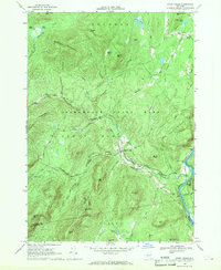
 1968 Lake Luzerne1970 Print · USGSThe upper Hudson River valley in the late sixties is shown here as the Delaware and Hudson railroad winds through the Adirondack foothills. Genealogists and hikers can locate the Old Methodist Cem, trace the roads near Danielstown, or explore the terrain around Lake Luzerne.3 unique versions available
End of results
Showing maps 1-8 of 8
Top cities near Lake Luzerne
- Queensbury historical maps
- Saratoga Springs historical maps
- Wilton historical maps
- Moreau historical maps
- Glens Falls historical maps
- Kingsbury historical maps
See more
Top neighborhoods of Lake Luzerne
- Hartman historical maps
- Danielstown historical maps
- Lake Vanare historical maps
- Beartown historical maps
- Lake Luzerne historical maps
Frequently asked questions
- What are the different types of historical maps available for Lake Luzerne?
- What is the oldest map of Lake Luzerne?
- Where can I purchase historical maps of Lake Luzerne for my home or office?
- Where can I download high-res historical maps of Lake Luzerne?
- Are there historical topographic maps available for Lake Luzerne?
- Is there historical aerial imagery available for Lake Luzerne?
- Where are historical maps of Lake Luzerne sourced from?