Old Maps of Harrisburg, Stony Creek for Academic Research
Study the evolution of Harrisburg with 11 high-resolution historic maps. Whether you're teaching, researching, or modeling changes in land use, these maps provide essential visual documentation of urban, environmental, and geographic change.
- Analyze long-term change: Track patterns in development, transportation, and natural features.
- Ideal for environmental or urban studies: Support academic projects with primary historical map data.
- Use in the classroom or lab: Educators and researchers rely on these maps to bring historical context to life.
These maps are a powerful tool for teaching, research, and visualizing how Harrisburg has changed over the decades.
Harrisburg, Stony Creek maps
(11)- 1910 Map of Stony Creek
 1910 Stony Creek1910 Print · USGSThe southern Adirondacks at the turn of the century are captured here, centered on the intersection of Hamilton, Warren, and Saratoga counties. Genealogists can trace early outposts and hamlets like Harrisburg West Stony Creek PO, Hope Falls, and Griffin.7 unique versions available
 - 1950 Map of Utica, 1951 Print
 1950 Utica1951 Print · USGSCentral New York in the post-war era showcases the industrial Mohawk Valley and the pristine Adirondack interior. Researchers can trace transportation networks like the New York Central Railroad and find early Cold War sites such as Griffiss Air Force Base.
 - 1954 Map of Harrisburg, 1958 Print
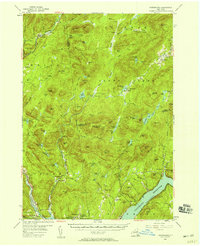 1954 Harrisburg1958 Print · USGSThe Adirondack foothills and the Sacandaga valley appear here in the mid-fifties, showing a landscape defined by mountain hamlets and seasonal camps. Researchers can trace family history through sites like Scofield Cem, the Edinburg Ch, and the remote settlement of Griffin.5 unique versions available
 - 1957 Map of Utica
 1957 Utica1957 Print · USGSCentral New York and the Adirondack foothills are captured here in the mid-fifties, showing a landscape defined by the Mohawk River corridor and the growing highway system. Genealogists and researchers can trace the rail lines of the New York Central and locate communities from Lowville to Gloversville.
 - 1962 Map of Utica
 1962 Utica1962 Print · USGSCentral New York and the Adirondack wilderness are captured here during the mid-century era of highway and industrial expansion. Genealogists and historians can trace the development of the New York State Thruway and local rail lines connecting Utica, Rome, and Gloversville.3 unique versions available
 - 1964 Map of Utica
 1964 Utica1964 Print · USGSCentral New York and the high wilderness of the Adirondacks are captured here during the post-war era of infrastructure expansion. Researchers can trace the development of the New York State Thruway alongside historic corridors like the Oneida Lake (Barge Canal Route) and the N. Y. Central railroad.
 - 1967 Map of Utica
 1967 Utica1967 Print · USGSCentral New York's industrial Mohawk Valley meets the Adirondack wilderness in the 1960s, showing the region's transition from manufacturing hubs to state-managed parklands. Trace historic settlements and sites like Griffiss Air Force Base, Colgate University, and the Lyons Falls Paper Mill.
 - 1985 Map of Gloversville, 1986 Print
 1985 Gloversville1986 Print · USGSThe southern Adirondacks meet the Mohawk Valley industrial corridor during the mid-eighties, showcasing a landscape of high-country lakes and riverside manufacturing towns. Trace the historical alignment of the Erie Canal and Conrail lines or locate landmarks like the Herkimer Home State Historic Site.2 unique versions available
 - 1990 Map of Harrisburg
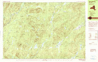 1990 Harrisburg1990 Print · USGSThe Adirondack backcountry near the Warren and Hamilton county lines is shown here in the 1990s as a landscape of isolated hamlets and mountain lakes. Researchers can trace the layout of small settlements like Harrisburg, Griffin, and Bakertown or locate remote water bodies including Wilcox Lake and Lens Lake.
 - 1997 Map of Harrisburg, 2000 Print
 1997 Harrisburg2000 Print · USGSThe Adirondack wilderness of the 1990s is captured here, showcasing the isolated settlements and vast forest preserves of Warren and Hamilton counties. Researchers can trace the quiet outposts of Harrisburg, Bakertown, and Knowelhurst alongside landmarks like Auger Falls and Girards Sugarbush.
 - 2023 Map of Harrisburg, 2023 Print
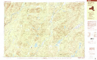
 2023 Harrisburg2023 Print · USGSThe mountain settlements of Warren County are captured in the 2020s, showing a landscape defined by high peaks and creek valleys. Genealogists can locate family burial sites like Van Dusen Cem and Scofield Cem near the hamlet of Knowelhurst.
End of results
Showing maps 1-11 of 11
Top cities near Harrisburg
- Greenfield historical maps
- Corinth historical maps
- Mayfield historical maps
- Warrensburg historical maps
- Chester historical maps
- Lake Luzerne historical maps
See more
Frequently asked questions
- What are the different types of historical maps available for Harrisburg?
- What is the oldest map of Harrisburg?
- Where can I purchase historical maps of Harrisburg for my home or office?
- Where can I download high-res historical maps of Harrisburg?
- Are there historical topographic maps available for Harrisburg?
- Is there historical aerial imagery available for Harrisburg?
- Where are historical maps of Harrisburg sourced from?