Old Maps of Easton, New York for Hiking & Exploration
Hike through history with 63 historic maps of Easton. Explore old trails, ghost towns, and forgotten backroads — perfect for outdoor adventurers and local explorers.
- Rediscover forgotten places: Map out old mining camps, roads, and footpaths that no longer exist on modern maps.
- Layer with modern tools: Combine with LiDAR or satellite views to plan hikes through historical terrain.
- Made for exploration: Popular among hikers, overlanders, and local history lovers.
Use these maps to find adventure and explore the hidden past of Easton.
Easton, NY maps
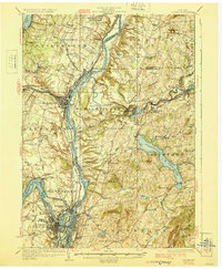
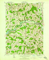
(63)- 1893 Map of Cohoes
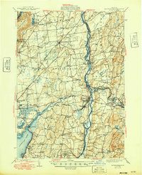
 1893 Cohoes1893 Print · USGSThe upper Hudson Valley and its industrial corridor come alive in the 1890s, from the streets of Cohoes to the Bemis Heights Battle Ground. Trace the original paths of the Erie Canal and Champlain Canal through Waterford and Mechanicsville.
 - 1895 Map of Cohoes
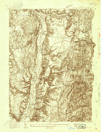
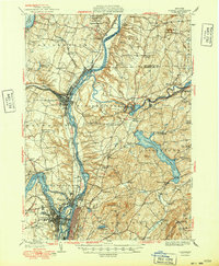
 1895 Cohoes1895 Print · USGSThe Hudson and Mohawk river valleys at the end of the nineteenth century reveal a landscape shaped by canal trade and burgeoning rail lines. Genealogists and local historians can trace the early layouts of Cohoes, Mechanicville, and the historic Battle Ground at Bemis Heights.
 - 1895 Map of Cambridge
 1895 Cambridge1895 Print · USGSWashington County, New York, is captured in the 1890s as a landscape of interconnected rail lines and riverside villages. Genealogists and historians can trace the paths of the Rutland and Washington R.R. through Salem or locate family roots in hamlets like Pumpkin Hook and Shushan.
 - 1897 Map of Hoosick
 1897 Hoosick1897 Print · USGSThe Hoosic River valley and Taconic foothills thrive at the peak of the rail era in the late nineteenth century. Genealogists and historians can trace the specific layouts of Hoosick Falls, Boyntonville, and the remote hamlets of Sodom and Factory Hollow.10 unique versions available
 - 1898 Map of Cambridge
 1898 Cambridge1898 Print · USGSWashington County at the close of the nineteenth century was a landscape of river-powered hamlets and busy rail corridors. Researchers can trace ancestral farmsteads and early industry near Batten Kill or explore the rail stops at Easton Sta. and Salem.
 - 1898 Map of Cohoes
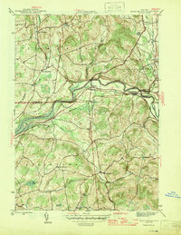
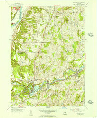
 1898 Cohoes1898 Print · USGSUpper Hudson Valley industry and transport are captured here at the end of the nineteenth century, from the confluence of the Mohawk to the hills of Pittstown. Trace the historic path of the Champlain Canal and the storied Battle Ground near Stillwater.8 unique versions available
 - 1900 Map of Taconic
 1900 Taconic1900 Print · USGSThe tri-state border region of the Taconic Mountains thrived at the turn of the century as a hub of rail travel and valley industry. Genealogists and historians can trace the early footprints of Hoosick Falls, Bennington, and the winding path of the Rutland R.R.4 unique versions available
 - 1900 Map of Schuylerville
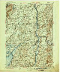
 1900 Schuylerville1900 Print · USGSUpper Hudson Valley life at the close of the nineteenth century centers on the busy canal and river corridor. Researchers can trace the Champlain Canal through Schuylerville and Fort Miller, or locate family sites near the Saratoga Battle Field and Gansevoort.7 unique versions available
 - 1901 Map of Cambridge
 1901 Cambridge1901 Print · USGSWashington County at the turn of the century is a landscape of river-powered industry and sprawling rail networks connecting New York to Vermont. Genealogists and historians can trace the paths of the Batten Kill, find old rail stops at Easton Sta., and locate vanished names like Pumpkin Hook.8 unique versions available
 - 1903 Map of Mettawee
 1903 Mettawee1903 Print · USGSThe New York and Vermont borderlands come alive in this turn-of-the-century survey of the Mettawee Valley. Genealogists can trace family footprints from Middletown Springs down to the Saratoga and Champlain Canal at Fort Ann.2 unique versions available
 - 1929 Map of Cohoes
 1929 Cohoes1929 Print · USGSThe industrial and revolutionary history of the Hudson Valley is clear in this late twenties survey of the river's confluence. Researchers can trace early rail stops at Stillwater Center Sta, explore the Saratoga Battlefield, or locate rural schoolhouses from School No 4 to School No 13.4 unique versions available
 - 1935 Map of Schuylerville
 1935 Schuylerville1935 Print · USGSThe Hudson River valley around Schuylerville and Greenwich is mapped here in the mid-1930s, showing the early evolution of the Saratoga region's industrial and historic landscape. Genealogists and historians can locate family landmarks like Rafferty Sch, the St Josephs Cem, and the now-quiet Champlain Canal (Abandoned).
 - 1940 Map of Schuylerville
 1940 Schuylerville1940 Print · USGSSaratoga and Washington Counties are shown here just before the mid-century, defined by the industrial river towns and the grounds of the Saratoga Battlefield. Genealogists can trace family names at Clarks Corners or Quaker Springs and locate early 20th-century landmarks like the Saratoga Battle Monument.3 unique versions available
 - 1944 Map of Cambridge, 1955 Print
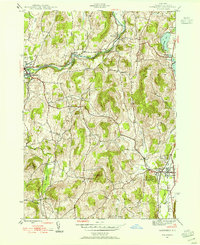 1944 Cambridge1955 Print · USGSMid-century Washington County reveals a landscape shaped by the Batten Kill and early rail corridors before the modern highway era. Researchers can trace historic property locations near Woodland Cem, rural schoolhouses like School No 1, and the rail lines of the Delaware and Hudson.3 unique versions available
 - 1944 Map of Eagle Bridge, 1958 Print
 1944 Eagle Bridge1958 Print · USGSThe Hoosic River valley during the mid-1940s reveals a landscape defined by riverside rail corridors and upland farming hamlets. Genealogists can trace family roots through Woodside Cem, rural schoolhouses, and small settlements like Buskirk and West Hoosick.3 unique versions available
 - 1946 Map of Eagle Bridge
 1946 Eagle Bridge1946 Print · USGSThe Hoosic River valley in the years following the war was a hub of small-town rail commerce and rural life. Genealogists and local historians can trace family roots through the clusters at Eagle Bridge, West Hoosick, and Center White Creek, or locate old landmarks like Woodside Cem and School No 2.2 unique versions available
 - 1946 Map of Cambridge
 1946 Cambridge1946 Print · USGSWashington County during the mid-forties reveals a landscape of river-valley rail towns and upland dairy farms. Genealogists and local historians can trace the foundations of Cambridge and Greenwich, locating specific landmarks like Woodland Cem and the Cary Sch.2 unique versions available
 - 1947 Map of Schuylerville, 1958 Print
 1947 Schuylerville1958 Print · USGSUpper Hudson Valley life and Revolutionary War heritage meet in the late 1940s. Trace the path of the Champlain Canal and find local landmarks like the Saratoga Battle Monument and the Fernwood Trout Hatchery.3 unique versions available
 - 1947 Map of Cohoes, 1968 Print
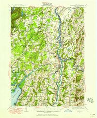
 1947 Cohoes1968 Print · USGSThe Hudson and Mohawk river valleys converge here in the mid-1940s, revealing a dense network of canals and early industrial railroads. Researchers can trace the Champlain Canal (Abandoned), find old rural schoolhouses, and locate landmarks like the Fire Lookout Tower and Cohoes Falls.
 - 1948 Map of Albany, 1951 Print
 1948 Albany1951 Print · USGSThe Hudson and Connecticut River valleys are captured here in the late 1940s, showing the vital rail and water corridors of the Northeast. You can trace the Boston and Maine tracks past Mt Greylock or locate early settlements like Great Barrington and Bennington.
 - 1949 Map of Schuylerville
 1949 Schuylerville1949 Print · USGSUpper Hudson Valley life in the late nineteen-forties centers on the river and its canal, shortly after the national park was established. Genealogists and historians can trace family locations near Victory Mills, old rural burial grounds like Griswold Cem, and the Fernwood Trout Hatchery.
 - 1949 Map of Cohoes
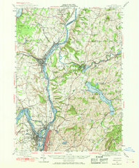
 1949 Cohoes1949 Print · USGSThe Hudson and Mohawk river valleys meet in the late 1940s at the industrial nexus of Cohoes and Troy. Local historians can trace early transport routes along the Champlain Canal, find family names near Bemis Heights, or locate old landmarks like the Fire Lookout Tower.2 unique versions available
 - 1950 Map of Glens Falls
 1950 Glens Falls1950 Print · USGSThe Adirondacks and the Green Mountains meet in this mid-century survey of the New York and Vermont borderlands. Researchers can trace the industrial rail corridors of the Rutland RR and Delaware & Hudson RR connecting Glens Falls, Rutland, and the shores of Lake George.
 - 1950 Map of Eagle Bridge, 1951 Print
 1950 Eagle Bridge1951 Print · USGSPost-war Upstate New York comes to life along the Hoosic River valley at the Washington and Rensselaer county line. Trace family roots through rural hamlets like Eagle Bridge, Buskirk, and West Hoosick, or locate old landmarks like School No 4 and Woodside Cem.
 - 1954 Map of Schaghticoke, 1956 Print
 1954 Schaghticoke1956 Print · USGSIn the mid-1950s, the Hoosic River valley hummed with industry and agriculture as rail lines connected thriving villages. Genealogists and historians can trace family ties at the Little Red Schoolhouse, St Johns Ch, and Elmwood Cemetery.4 unique versions available
Showing maps 1-25 of 63
Top cities near Easton
- Colonie historical maps
- Clifton Park historical maps
- Queensbury historical maps
- Saratoga Springs historical maps
- Halfmoon historical maps
- Wilton historical maps
See more
Top neighborhoods of Easton
- North Easton historical maps
- Crandall Corners historical maps
- Archdale historical maps
- South Easton historical maps
- Barkers Grove historical maps
Frequently asked questions
- What are the different types of historical maps available for Easton?
- What is the oldest map of Easton?
- Where can I purchase historical maps of Easton for my home or office?
- Where can I download high-res historical maps of Easton?
- Are there historical topographic maps available for Easton?
- Is there historical aerial imagery available for Easton?
- Where are historical maps of Easton sourced from?