1950s Maps of Sodus, New York
Explore 7 historic maps of Sodus from the 1950s. These maps offer a rare glimpse into what life looked like during the 1950s — showing old roads, neighborhoods, homes, and landmarks that have changed or disappeared over time.
Whether you're researching your family's past, planning a metal detecting trip, or studying how Sodus's landscape evolved across the 1950s, these high-resolution maps are a powerful tool for exploring the history of this region.
- Focus on a specific era: All maps on this page are from the 1950s, giving you a focused view of this time period.
- See what’s changed: Compare century-old streets, trails, and buildings to today's modern landscape using overlays and satellite layers.
- Research with precision: Use these maps for genealogy, historical research, land use analysis, or educational projects.
- View, download, or print: Maps are fully viewable online in high resolution, and can be downloaded or printed for your own records.
Start exploring Sodus's history through authentic maps from the 1950s. This is your window into the past.
Sodus, NY maps
(7)- 1952 Map of Salmon Creek, 1953 Print
 1952 Salmon Creek1953 Print · USGSThe Lake Ontario shoreline in Wayne County comes into focus during the early fifties, showing a rural landscape of orchards and coastal bluffs. Researchers can trace family roots at Centenary Cem or locate the old Pennsylvania rail line near Maxwell Bay.
 - 1952 Map of Pultneyville, 1953 Print
 1952 Pultneyville1953 Print · USGSThe Lake Ontario shoreline in Wayne County appears here in the early fifties, centering on the historic port of Pultneyville. Local researchers can trace family lands along Lonesome Road or locate the Lakeview Cem near the mouth of Salmon Creek.3 unique versions available
 - 1952 Map of Williamson, 1953 Print
 1952 Williamson1953 Print · USGSWayne County's agricultural heartland is documented here in the early fifties, showing a landscape defined by orchards and glacial ridges. You can trace family history through rural sites like Hall Center Cem, the hamlet of Owls Nest, and the busy rail corridors of the New York Central.3 unique versions available
 - 1952 Map of Sodus, 1954 Print
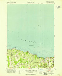
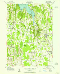
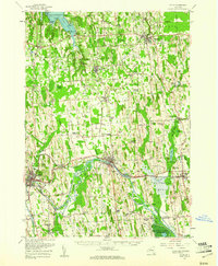
 1952 Sodus1954 Print · USGSWayne County agricultural and rail corridors are frozen in time just after the war. Local historians can trace the paths of the New York Central and Pennsylvania railroads through Wallington and Sodus Center, and locate rural landmarks like School No 7 or Parish church.2 unique versions available
 - 1953 Map of Rose, 1955 Print
 1953 Rose1955 Print · USGSWayne County's lakeshore and farming hamlets are preserved here in the mid-fifties, showing the region's rail-dependent rural economy. You can trace family roots through Rose Cem, locate the rail stops at North Rose, or explore the shoreline at Bonni Castle.4 unique versions available
 - 1953 Map of Sodus Point, 1955 Print
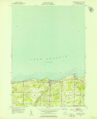
 1953 Sodus Point1955 Print · USGSThe Wayne County shoreline and the protected waters of Sodus Bay are captured here in the early fifties. Local historians can trace the rail terminus at Sodus Point, the lakeside community of Lake Bluff, and rural landmarks like St Johns Chapel.4 unique versions available
 - 1953 Map of Clyde, 1961 Print
 1953 Clyde1961 Print · USGSWayne County is shown in the early fifties, defined by the industrial hubs of Lyons and Clyde along the historic Erie Canal. Researchers can trace old family sites at Lockwood Corners, locate the White Schoolhouse, or find the Rice Mill near the marshlands.
End of results
Showing maps 1-7 of 7
Top cities near Sodus
- Farmington historical maps
- Arcadia historical maps
- Ontario historical maps
- Manchester historical maps
- Macedon historical maps
- Walworth historical maps
See more
Top neighborhoods of Sodus
- Thorntons Corner historical maps
- Joy historical maps
- Alton historical maps
- South Sodus historical maps
- Wallington historical maps
- Sodus Center historical maps
See more
Frequently asked questions
- What are the different types of historical maps available for Sodus?
- What is the oldest map of Sodus?
- Where can I purchase historical maps of Sodus for my home or office?
- Where can I download high-res historical maps of Sodus?
- Are there historical topographic maps available for Sodus?
- Is there historical aerial imagery available for Sodus?
- Where are historical maps of Sodus sourced from?