1950s Maps of Bedford, New York
Explore 3 historic maps of Bedford from the 1950s. These maps offer a rare glimpse into what life looked like during the 1950s — showing old roads, neighborhoods, homes, and landmarks that have changed or disappeared over time.
Whether you're researching your family's past, planning a metal detecting trip, or studying how Bedford's landscape evolved across the 1950s, these high-resolution maps are a powerful tool for exploring the history of this region.
- Focus on a specific era: All maps on this page are from the 1950s, giving you a focused view of this time period.
- See what’s changed: Compare century-old streets, trails, and buildings to today's modern landscape using overlays and satellite layers.
- Research with precision: Use these maps for genealogy, historical research, land use analysis, or educational projects.
- View, download, or print: Maps are fully viewable online in high resolution, and can be downloaded or printed for your own records.
Start exploring Bedford's history through authentic maps from the 1950s. This is your window into the past.
Bedford, NY maps
(3)- 1951 Map of Pound Ridge, 1953 Print
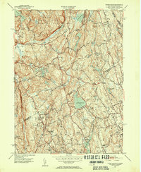 1951 Pound Ridge1953 Print · USGSThe New York and Connecticut borderlands appear here in the early fifties, showing the rural character of Westchester and Fairfield counties before significant suburbanization. Trace local heritage through family landmarks like Becks Hill and numerous burial sites such as Pound Ridge Cem and Waterbury Cem.3 unique versions available
 - 1955 Map of Mount Kisco, 1956 Print
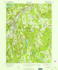 1955 Mount Kisco1956 Print · USGSUpper Westchester County is seen here during the mid-fifties, showing the sophisticated estate-and-commuter landscape of New York and Connecticut. Trace family history at Oakwood Cem, the Old Quaker Burial Ground, or local landmarks like Westfield State Farm.5 unique versions available
 - 1958 Map of Peach Lake, 1960 Print
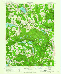 1958 Peach Lake1960 Print · USGSThe New York and Connecticut state line bisects this mid-century landscape of reservoir waters and quiet village centers. Genealogists and local historians can trace family sites at Mead Cem, St Johns Ch, and the old Township Sch.7 unique versions available
End of results
Showing maps 1-3 of 3
Top cities near Bedford
- Huntington historical maps
- Stamford historical maps
- Greenburgh historical maps
- Clarkstown historical maps
- Norwalk historical maps
- Danbury historical maps
See more
Top neighborhoods of Bedford
- Bedford Center historical maps
- Bedford Four Corners historical maps
- Katonah Ridge historical maps
- Bedford Hills historical maps
- Katonah historical maps
Frequently asked questions
- What are the different types of historical maps available for Bedford?
- What is the oldest map of Bedford?
- Where can I purchase historical maps of Bedford for my home or office?
- Where can I download high-res historical maps of Bedford?
- Are there historical topographic maps available for Bedford?
- Is there historical aerial imagery available for Bedford?
- Where are historical maps of Bedford sourced from?