1960s Maps of Mount Pleasant, New York
Explore 8 historic maps of Mount Pleasant from the 1960s. These maps offer a rare glimpse into what life looked like during the 1960s — showing old roads, neighborhoods, homes, and landmarks that have changed or disappeared over time.
Whether you're researching your family's past, planning a metal detecting trip, or studying how Mount Pleasant's landscape evolved across the 1960s, these high-resolution maps are a powerful tool for exploring the history of this region.
- Focus on a specific era: All maps on this page are from the 1960s, giving you a focused view of this time period.
- See what’s changed: Compare century-old streets, trails, and buildings to today's modern landscape using overlays and satellite layers.
- Research with precision: Use these maps for genealogy, historical research, land use analysis, or educational projects.
- View, download, or print: Maps are fully viewable online in high resolution, and can be downloaded or printed for your own records.
Start exploring Mount Pleasant's history through authentic maps from the 1960s. This is your window into the past.
Mount Pleasant, NY maps
(8)- 1960 Map of Glenville, 1962 Print
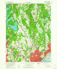 1960 Glenville1962 Print · USGSThe Connecticut and New York borderlands are seen here in the early sixties, as suburban growth transformed the wooded landscape between the reservoir and the sound. Genealogists and local historians can trace legacy institutions like Manhattanville College, the Harkness Home, and the Blind Brook Polo Club.4 unique versions available
 - 1961 Map of Hartford
 1961 Hartford1961 Print · USGSSouthern New England and the Hudson Valley are shown here in the mid-fifties, capturing a landscape of booming coastal cities and interior hill towns. Researchers can trace the legacy of the New York New Haven and Hartford rail corridor and find strategic sites like Camp Shanks and Fort Michie.
 - 1962 Map of Hartford, 1971 Print
 1962 Hartford1971 Print · USGSSouthern New England and the Hudson Valley are shown in the early sixties, as suburban growth reached into the foothills. Trace the path of the New York New Haven & Hartford RR and find landmarks like Camp Nathan Hale and Gillette Castle State Park.3 unique versions available
 - 1965 Map of Hartford
 1965 Hartford1965 Print · USGSSouthern New England and the Hudson Valley are shown here during the mid-sixties expansion of the Interstate era. Trace the path of the New York New Haven & Hartford RR or locate historic landmarks like West Point Military Reservation and the Merritt Parkway.2 unique versions available
 - 1967 Map of Nyack, 1969 Print
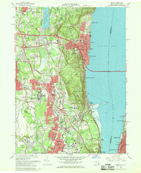 1967 Nyack1969 Print · USGSThe Hudson River's western shore in the late sixties reveals a landscape of established riverfront villages and growing suburban institutions. Genealogists and historians can trace Oak Hill Cemetery, the Rockland State Hospital, and the historic enclave at Sneden Landing.3 unique versions available
 - 1967 Map of Ossining, 1969 Print
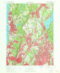
 1967 Ossining1969 Print · USGSWestchester County in the mid-sixties reveals a landscape of massive civil engineering and academic institutions. Trace the historic Old Croton Aqueduct, locate the riverside Sing Sing Prison, and explore old landmarks like Maryknoll Seminary and the Emery Mines.4 unique versions available
 - 1967 Map of White Plains, 1969 Print
 1967 White Plains1969 Print · USGSSuburban Westchester County comes into focus in the late sixties as new parkways and residential developments expand between the Hudson River and White Plains. Trace family sites at Sleepy Hollow Cemetery, Marymount College, and the sprawling Kensico Cemetery.3 unique versions available
 - 1967 Map of Haverstraw, 1969 Print
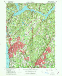
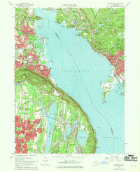 1967 Haverstraw1969 Print · USGSThe Hudson River's wide Haverstraw Bay is captured here in the late sixties, showing the suburban growth of Rockland and Westchester counties. Genealogists can locate family landmarks like Hillside Cem, Mount Repose Cemetery, and the Stony Point Lighthouse.
End of results
Showing maps 1-8 of 8
Top cities near Mount Pleasant
- New York historical maps
- Oyster Bay historical maps
- North Hempstead historical maps
- Yonkers historical maps
- Ramapo historical maps
- Stamford historical maps
See more
Top neighborhoods of Mount Pleasant
- Graham historical maps
- Archville historical maps
- Sleepy Hollow historical maps
- Pleasantville historical maps
- Hawthorne historical maps
- Thornwood historical maps
See more
Frequently asked questions
- What are the different types of historical maps available for Mount Pleasant?
- What is the oldest map of Mount Pleasant?
- Where can I purchase historical maps of Mount Pleasant for my home or office?
- Where can I download high-res historical maps of Mount Pleasant?
- Are there historical topographic maps available for Mount Pleasant?
- Is there historical aerial imagery available for Mount Pleasant?
- Where are historical maps of Mount Pleasant sourced from?