1900-1909 Maps of Milo, New York
Explore 2 historic maps of Milo from 1900-1909. These maps offer a rare glimpse into what life looked like during the 1900s — showing old roads, neighborhoods, homes, and landmarks that have changed or disappeared over time.
Whether you're researching your family's past, planning a metal detecting trip, or studying how Milo's landscape evolved across the 1900s, these high-resolution maps are a powerful tool for exploring the history of this region.
- Focus on a specific era: All maps on this page are from the 1900s, giving you a focused view of this time period.
- See what’s changed: Compare century-old streets, trails, and buildings to today's modern landscape using overlays and satellite layers.
- Research with precision: Use these maps for genealogy, historical research, land use analysis, or educational projects.
- View, download, or print: Maps are fully viewable online in high resolution, and can be downloaded or printed for your own records.
Start exploring Milo's history through authentic maps from the 1900s. This is your window into the past.
Milo, NY maps
(2)- 1902 Map of Ovid
 1902 Ovid1902 Print · USGSThe Finger Lakes region at the turn of the century shows a landscape tied together by steamboats and competing rail lines. Genealogists and historians can trace the industrial footprints of Cascade Mills or follow the path of the Lehigh Valley R. R. through villages like Ovid and Lodi.9 unique versions available
 - 1903 Map of Penn Yan
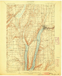 1903 Penn Yan1903 Print · USGSThe Finger Lakes region thrives at the turn of the century, centered on the busy steamboat and rail docks of Penn Yan. Trace early industry along the Keuka Lake Outlet or locate family roots in Branchport, Milo Center, and Keuka Park.7 unique versions available
End of results
Showing maps 1-2 of 2
Top cities near Milo
- Geneva historical maps
- Penn Yan historical maps
- Hector historical maps
- Jerusalem historical maps
- Gorham historical maps
- Fayette historical maps
See more
Top neighborhoods of Milo
- Milo Center historical maps
- Willow Grove historical maps
- Randall Crossing historical maps
- Seneca Mills historical maps
- Keuka Mills historical maps
- Second Milo historical maps
See more
Frequently asked questions
- What are the different types of historical maps available for Milo?
- What is the oldest map of Milo?
- Where can I purchase historical maps of Milo for my home or office?
- Where can I download high-res historical maps of Milo?
- Are there historical topographic maps available for Milo?
- Is there historical aerial imagery available for Milo?
- Where are historical maps of Milo sourced from?