1940s Maps of Milo, New York
Explore 6 historic maps of Milo from the 1940s. These maps offer a rare glimpse into what life looked like during the 1940s — showing old roads, neighborhoods, homes, and landmarks that have changed or disappeared over time.
Whether you're researching your family's past, planning a metal detecting trip, or studying how Milo's landscape evolved across the 1940s, these high-resolution maps are a powerful tool for exploring the history of this region.
- Focus on a specific era: All maps on this page are from the 1940s, giving you a focused view of this time period.
- See what’s changed: Compare century-old streets, trails, and buildings to today's modern landscape using overlays and satellite layers.
- Research with precision: Use these maps for genealogy, historical research, land use analysis, or educational projects.
- View, download, or print: Maps are fully viewable online in high resolution, and can be downloaded or printed for your own records.
Start exploring Milo's history through authentic maps from the 1940s. This is your window into the past.
Milo, NY maps
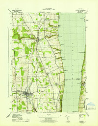
(6)- 1942 Map of Penn Yan
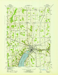 1942 Penn Yan1942 Print · USGSThe northern tip of Keuka Lake and the village of Penn Yan are captured here just as the region’s milling and rail economy reached a mid-century peak. Genealogists can trace family lands along Finger Road or locate ancestors in Mt Pleasant Cem and numerous rural school districts.4 unique versions available
 - 1942 Map of Dundee, 1957 Print
 1942 Dundee1957 Print · USGSThe western shores of Seneca Lake appear in the early 1940s, revealing a landscape defined by parallel rail lines and lakeside landings. Genealogists and local historians can trace the foundations of Dundee, the grounds of Lakemont Academy, and the routes of the New York Central Railroad.3 unique versions available
 - 1942 Map of Keuka Park, 1960 Print
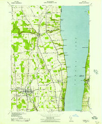
 1942 Keuka Park1960 Print · USGSKeuka Lake and its western shore appear here during the early war years, showing the rural character of Yates County. Genealogists can trace family roots through numerous district schools and landmarks like Keuka College, Second Milo, and the Barrington Cem.3 unique versions available
 - 1943 Map of Dresden
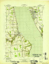 1943 Dresden1943 Print · USGSDuring the early years of the Second World War, the Seneca Lake shore underwent a massive transformation with the establishment of the Naval Training Station. Researchers can trace the layout of the station and Sampson (PO), or locate historic mills like Mays Mills and Cascade Mills.4 unique versions available
 - 1943 Map of Keuka Lake
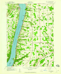
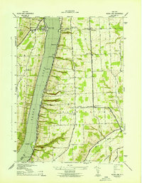 1943 Keuka Lake1943 Print · USGSThe Finger Lakes region of the early 1940s is shown here, centered on the eastern waters and rural uplands of the lake. Genealogists can trace family connections through numerous rural landmarks like Second Milo, School No 3, and the Barrington Cem.
 - 1943 Map of Dundee
 1943 Dundee1943 Print · USGSThe western shores of Seneca Lake and the village of Dundee are captured here during the Second World War. Genealogists can trace family names and properties near Lakemont Academy, Hillside Cemetery, and the rail stops at Randall Crossing.
End of results
Showing maps 1-6 of 6
Top cities near Milo
- Geneva historical maps
- Penn Yan historical maps
- Hector historical maps
- Jerusalem historical maps
- Gorham historical maps
- Fayette historical maps
See more
Top neighborhoods of Milo
- Milo Center historical maps
- Willow Grove historical maps
- Randall Crossing historical maps
- Seneca Mills historical maps
- Keuka Mills historical maps
- Second Milo historical maps
See more
Frequently asked questions
- What are the different types of historical maps available for Milo?
- What is the oldest map of Milo?
- Where can I purchase historical maps of Milo for my home or office?
- Where can I download high-res historical maps of Milo?
- Are there historical topographic maps available for Milo?
- Is there historical aerial imagery available for Milo?
- Where are historical maps of Milo sourced from?