1940s Maps of Navassa, North Carolina
Explore 5 historic maps of Navassa from the 1940s. These maps offer a rare glimpse into what life looked like during the 1940s — showing old roads, neighborhoods, homes, and landmarks that have changed or disappeared over time.
Whether you're researching your family's past, planning a metal detecting trip, or studying how Navassa's landscape evolved across the 1940s, these high-resolution maps are a powerful tool for exploring the history of this region.
- Focus on a specific era: All maps on this page are from the 1940s, giving you a focused view of this time period.
- See what’s changed: Compare century-old streets, trails, and buildings to today's modern landscape using overlays and satellite layers.
- Research with precision: Use these maps for genealogy, historical research, land use analysis, or educational projects.
- View, download, or print: Maps are fully viewable online in high resolution, and can be downloaded or printed for your own records.
Start exploring Navassa's history through authentic maps from the 1940s. This is your window into the past.
Navassa, NC maps
(5)- 1942 Map of Wilmington
 1942 Wilmington1942 Print · USGSWilmington and its coastal sounds are shown during the early years of the war, when the riverfront and beach communities were expanding. Researchers can trace family-named landmarks like Everett Creek, the riverside Ruins Anderson Landing, and the seaside Seabreeze resort.
 - 1943 Map of Winnabow, 1962 Print
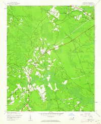 1943 Winnabow1962 Print · USGSCoastal North Carolina's rural interior comes into focus here during the early 1940s, showing a landscape defined by timber, swamps, and small community hubs. Researchers can trace family history through old landmarks like Bell Swamp Sch, Benton Cem, and the Abandoned Railroad Grade.2 unique versions available
 - 1944 Map of Winnabow
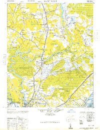
 1944 Winnabow1944 Print · USGSCoastal Brunswick County is captured here during the mid-forties, showing a landscape defined by tidewater creeks and rural crossroads. Researchers can trace family sites and local landmarks like Winnabow School, Nelson Cem, and the discontinued Wilmington Brunswick and Southern railroad.
 - 1947 Map of Rocky Point
 1947 Rocky Point1947 Print · USGSCoastal North Carolina just after the war shows a landscape of river-bend settlements and expanding rail lines. You can trace old family routes along Merricks Lane Road, locate historic sites like St. James Ch, and see the early industry at Castle Hayne.
 - 1948 Map of Wilmington
 1948 Wilmington1948 Print · USGSWilmington and the New Hanover coast are captured here in the late 1940s, as the region's river-based industry and beach communities began their post-war expansion. Researchers can trace historical sites from the Ruins Anderson Landing to urban landmarks like Union Station and Customs House.2 unique versions available
End of results
Showing maps 1-5 of 5
Top cities near Navassa
- Wilmington historical maps
- Leland historical maps
- Boiling Spring Lakes historical maps
- Carolina Beach historical maps
- Wrightsville Beach historical maps
- Northwest historical maps
See more
Top neighborhoods of Navassa
Frequently asked questions
- What are the different types of historical maps available for Navassa?
- What is the oldest map of Navassa?
- Where can I purchase historical maps of Navassa for my home or office?
- Where can I download high-res historical maps of Navassa?
- Are there historical topographic maps available for Navassa?
- Is there historical aerial imagery available for Navassa?
- Where are historical maps of Navassa sourced from?