1950s Maps of Navassa, North Carolina
Explore 6 historic maps of Navassa from the 1950s. These maps offer a rare glimpse into what life looked like during the 1950s — showing old roads, neighborhoods, homes, and landmarks that have changed or disappeared over time.
Whether you're researching your family's past, planning a metal detecting trip, or studying how Navassa's landscape evolved across the 1950s, these high-resolution maps are a powerful tool for exploring the history of this region.
- Focus on a specific era: All maps on this page are from the 1950s, giving you a focused view of this time period.
- See what’s changed: Compare century-old streets, trails, and buildings to today's modern landscape using overlays and satellite layers.
- Research with precision: Use these maps for genealogy, historical research, land use analysis, or educational projects.
- View, download, or print: Maps are fully viewable online in high resolution, and can be downloaded or printed for your own records.
Start exploring Navassa's history through authentic maps from the 1950s. This is your window into the past.
Navassa, NC maps
(6)- 1950 Map of Winnabow
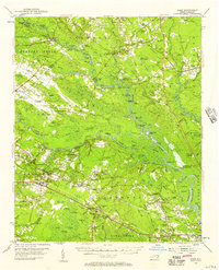
 1950 Winnabow1950 Print · USGSCoastal Brunswick County is shown here during a mid-century period of shifting transit as rail service was winding down. Genealogists can locate family landmarks like Dora Benton Cem, Easy Hill, and the Wayside Church near Winnabow.
 - 1953 Map of Florence, 1964 Print
 1953 Florence1964 Print · USGSThe Carolina borderlands in the mid-fifties were a landscape of vast river swamps and rising rail towns. Trace the legacy of the Seaboard Air Line through Florence or explore the wetlands surrounding Lake Waccamaw and the Green Swamp.3 unique versions available
 - 1953 Map of Beaufort, 1965 Print
 1953 Beaufort1965 Print · USGSThe North Carolina coastline in the mid-fifties reveals an era of massive military expansion alongside traditional maritime life. Genealogists can trace family names and small settlements from Sealevel to Sneads Ferry or locate landmarks like Fort Macon.3 unique versions available
 - 1954 Map of Florence
 1954 Florence1954 Print · USGSThe Carolinas borderlands come alive in the early fifties, showing the vital rail-and-river networks of the coastal plain. Genealogists can trace family footprints across the Green Swamp or through settlements like Red Springs, Chadbourn, and McColl.
 - 1954 Map of Beaufort
 1954 Beaufort1954 Print · USGSCoastal North Carolina in the mid-fifties reveals a landscape of strategic military installations, sprawling wetlands, and thriving rail towns. Genealogists and historians can trace the foundations of Wilmington, the rural reaches of Duplin County, and shoreline landmarks like Cape Lookout and Carolina Beach.
 - 1954 Map of Acme, 1957 Print
 1954 Acme1957 Print · USGSCoastal North Carolina river life in the mid-fifties centered on the confluence of the Cape Fear and the Black River. Genealogists can trace family names at Still Bluff and Maultbys Point, or locate the historic Lincoln High Sch and Farmers Chapel.2 unique versions available
End of results
Showing maps 1-6 of 6
Top cities near Navassa
- Wilmington historical maps
- Leland historical maps
- Boiling Spring Lakes historical maps
- Carolina Beach historical maps
- Wrightsville Beach historical maps
- Northwest historical maps
See more
Top neighborhoods of Navassa
Frequently asked questions
- What are the different types of historical maps available for Navassa?
- What is the oldest map of Navassa?
- Where can I purchase historical maps of Navassa for my home or office?
- Where can I download high-res historical maps of Navassa?
- Are there historical topographic maps available for Navassa?
- Is there historical aerial imagery available for Navassa?
- Where are historical maps of Navassa sourced from?