1990s Maps of Navassa, North Carolina
Explore 6 historic maps of Navassa from the 1990s. These maps offer a rare glimpse into what life looked like during the 1990s — showing old roads, neighborhoods, homes, and landmarks that have changed or disappeared over time.
Whether you're researching your family's past, planning a metal detecting trip, or studying how Navassa's landscape evolved across the 1990s, these high-resolution maps are a powerful tool for exploring the history of this region.
- Focus on a specific era: All maps on this page are from the 1990s, giving you a focused view of this time period.
- See what’s changed: Compare century-old streets, trails, and buildings to today's modern landscape using overlays and satellite layers.
- Research with precision: Use these maps for genealogy, historical research, land use analysis, or educational projects.
- View, download, or print: Maps are fully viewable online in high resolution, and can be downloaded or printed for your own records.
Start exploring Navassa's history through authentic maps from the 1990s. This is your window into the past.
Navassa, NC maps
(6)- 1990 Map of Wilmington
 1990 Wilmington1990 Print · USGSThe North Carolina coast in the early nineties reveals a landscape defined by the convergence of the Cape Fear River and the Atlantic shore. Genealogists and historians can trace suburban growth and maritime infrastructure from the inland Kendall Chapel to coastal hubs like Wrightsville Beach and Carolina Beach.
 - 1990 Map of Whiteville
 1990 Whiteville1990 Print · USGSSoutheastern North Carolina and the South Carolina borderlands appear in the late twentieth century, showing a landscape of river-swamps and tobacco towns. Researchers can trace family history through sites like Mount Olive Ch, the Seaboard Coast Line RR, and rural centers like Tabor City.
 - 1990 Map of Winnabow, 1991 Print
 1990 Winnabow1991 Print · USGSCoastal Brunswick County comes into focus in this late-century survey of the terrain surrounding Town Creek and Leland. Researchers can trace old transportation routes and community landmarks like the Old Railroad Grade, Winnabow Airport, and Damascus Rd Ch.2 unique versions available
 - 1993 Map of Wilmington, 1999 Print
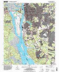 1993 Wilmington1999 Print · USGSWilmington and its surrounding riverfront communities are captured here in the 1990s as the city expanded southward toward Myrtle Grove. Genealogists and local historians can trace family roots through landmarks like St Thomas Cem and Providence Missionary Ch or locate the historic Old Town area.
 - 1997 Map of Castle Hayne, 2000 Print
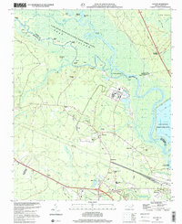
 1997 Castle Hayne2000 Print · USGSCoastal New Hanover County transitions from the industrial riverbanks of the late nineties to the growing suburban reaches north of the city. Genealogists and local historians can trace the foundations of Castle Hayne and Wrightsboro, or locate sites like St Stanislaus Ch and Cowpen Landing.
 - 1997 Map of Leland, 2001 Print
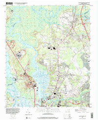
 1997 Leland2001 Print · USGSCoastal North Carolina river life meets industrial growth in the 1990s as the Cape Fear River meanders through Brunswick County. Researchers can trace historic river landings like Peachtree Landing alongside community hubs like Phoenix, the Lincoln Sch, and New Hope Ch.
End of results
Showing maps 1-6 of 6
Top cities near Navassa
- Wilmington historical maps
- Leland historical maps
- Boiling Spring Lakes historical maps
- Carolina Beach historical maps
- Wrightsville Beach historical maps
- Northwest historical maps
See more
Top neighborhoods of Navassa
Frequently asked questions
- What are the different types of historical maps available for Navassa?
- What is the oldest map of Navassa?
- Where can I purchase historical maps of Navassa for my home or office?
- Where can I download high-res historical maps of Navassa?
- Are there historical topographic maps available for Navassa?
- Is there historical aerial imagery available for Navassa?
- Where are historical maps of Navassa sourced from?