1990s Maps of Mulberry, North Carolina
Explore 1 historic maps of Mulberry from the 1990s. These maps offer a rare glimpse into what life looked like during the 1990s — showing old roads, neighborhoods, homes, and landmarks that have changed or disappeared over time.
Whether you're researching your family's past, planning a metal detecting trip, or studying how Mulberry's landscape evolved across the 1990s, these high-resolution maps are a powerful tool for exploring the history of this region.
- Focus on a specific era: All maps on this page are from the 1990s, giving you a focused view of this time period.
- See what’s changed: Compare century-old streets, trails, and buildings to today's modern landscape using overlays and satellite layers.
- Research with precision: Use these maps for genealogy, historical research, land use analysis, or educational projects.
- View, download, or print: Maps are fully viewable online in high resolution, and can be downloaded or printed for your own records.
Start exploring Mulberry's history through authentic maps from the 1990s. This is your window into the past.
Mulberry, NC maps
(1)- 1994 Map of Globe, 1998 Print
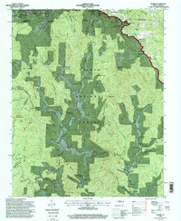 1994 Globe1998 Print · USGSCaldwell County’s mountain hollows and high ridges are shown here in the mid-1990s, where the Blue Ridge Parkway meets the northern forest. Genealogists and historians can locate numerous family burial sites and rural meeting places, including White Spring Cemetery, Globe Church, and the settlement at Upton.
End of results
Showing maps 1-1 of 1
Top cities near Mulberry
- Boone historical maps
- Lenoir historical maps
- Sawmills historical maps
- Granite Falls historical maps
- Gamewell historical maps
- Hudson historical maps
See more
Frequently asked questions
- What are the different types of historical maps available for Mulberry?
- What is the oldest map of Mulberry?
- Where can I purchase historical maps of Mulberry for my home or office?
- Where can I download high-res historical maps of Mulberry?
- Are there historical topographic maps available for Mulberry?
- Is there historical aerial imagery available for Mulberry?
- Where are historical maps of Mulberry sourced from?