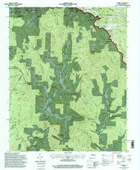
1994 Map of Globe
USGS Topo · Published 1998About this map
Pisgah National Forest encompasses the vast majority of this landscape in western Caldwell County, where the topography rises sharply toward the Blue Ridge escarpment. The settlement of Globe sits at the confluence of several mountain drainages, including Johns River and Gragg Creek, serving as a central point for a network of rural roads and family cemeteries. Higher elevations are marked by the Blue Ridge Parkway winding along the northern edge, passing near Blowing Rock and through Julian Price Memorial Park. This 1994 revision highlights the distribution of historic community landmarks such as Bailey Camp Church and the Edmisten Cemetery, which remain anchored in the hollows between prominent landforms like Backbone Ridge and Globe Mountain. The drainage patterns, particularly Thunderhole Creek and Mulberry Creek, illustrate how the rugged terrain dictated the placement of small mountain settlements and homesteads.
Find a feature on this map
83 named features on this map. Tap any name to fly to it.
Don’t see what you’re looking for? This feature index may not catch every label — zoom into the map to look around manually.
Map Details
Editions of this 1994 Globe Map
This is the sole edition of this map. No revisions or reprints were ever made.
Other maps of this area

1893 · Cranberry
USGS Topo · 1:125,000

1895 · Cranberry
USGS Topo · 1:125,000

1899 · Cranberry
USGS Topo · 1:125,000

1902 · Cranberry
USGS Topo · 1:125,000

1905 · Morganton
USGS Topo · 1:125,000

1934 · Valle Crucis
USGS Topo · 1:24,000

1934 · Boone
USGS Topo · 1:24,000

1936 · Blowing Rock
USGS Topo · 1:48,000

1942 · Blowing Rock
USGS Topo · 1:62,500

1944 · Linville
USGS Topo · 1:62,500