
1905 Map of Morganton
USGS Topo · Published 1941About this map
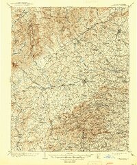
Morganton and Lenoir serve as the primary hubs in this early twentieth-century landscape, connected by a network of wagon roads and the Southern Railway. The terrain is defined by the sharp descent of the Catawba River and its numerous tributaries, including Wilson Creek and Silver Creek. Education and industry are represented by sites such as Rutherford College, Amherst College, and the riverside operations at Mill Shoals. To the west, the dramatic topography of the Blue Ridge escarpment is anchored by Linville Falls and the towering heights of Tablerock Mt and Hawksbill Mt. The map captures a moment when rural commerce thrived at local nodes like Arneys Store and Linvilles Store, while industrial and residential pockets such as Valdese and Glen Alpine began to take shape along the rail corridor. Further south and west, the landscape is dotted with family-named peaks and knobs, reflecting the deep-rooted settlement patterns of the Catawba Valley.
Find a feature on this map
192 named features on this map. Tap any name to fly to it.
Don’t see what you’re looking for? This feature index may not catch every label — zoom into the map to look around manually.
Map Details
Editions of this 1905 Morganton Map
2 editions found
Other maps of this area

1889 · Wilkesboro
USGS Topo · 1:125,000

1891 · Roan Mountain
USGS Topo · 1:125,000

1891 · Wilkesboro
USGS Topo · 1:125,000

1893 · Cranberry
USGS Topo · 1:125,000

1894 · Roan Mountain
USGS Topo · 1:125,000

1895 · Hickory
USGS Topo · 1:125,000

1895 · Cranberry
USGS Topo · 1:125,000

1899 · Cranberry
USGS Topo · 1:125,000

1900 · Mount Mitchell
USGS Topo · 1:125,000

1902 · Cranberry
USGS Topo · 1:125,000