1940s Maps of Emerald Isle, North Carolina
Explore 3 historic maps of Emerald Isle from the 1940s. These maps offer a rare glimpse into what life looked like during the 1940s — showing old roads, neighborhoods, homes, and landmarks that have changed or disappeared over time.
Whether you're researching your family's past, planning a metal detecting trip, or studying how Emerald Isle's landscape evolved across the 1940s, these high-resolution maps are a powerful tool for exploring the history of this region.
- Focus on a specific era: All maps on this page are from the 1940s, giving you a focused view of this time period.
- See what’s changed: Compare century-old streets, trails, and buildings to today's modern landscape using overlays and satellite layers.
- Research with precision: Use these maps for genealogy, historical research, land use analysis, or educational projects.
- View, download, or print: Maps are fully viewable online in high resolution, and can be downloaded or printed for your own records.
Start exploring Emerald Isle's history through authentic maps from the 1940s. This is your window into the past.
Emerald Isle, NC maps
(3)- 1942 Map of Swansboro
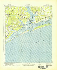 1942 Swansboro1942 Print · USGSThe North Carolina coast during the early 1940s reveals a world of intricate waterways and family-named landings before mid-century development. Genealogists and historians can trace old sites like Snead Ferry, Willis Landing, and the inland hub of Whitehouse Forks.
 - 1948 Map of Swansboro
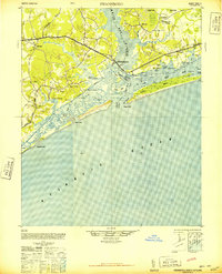 1948 Swansboro1948 Print · USGSCoastal North Carolina's maritime character is preserved here in the late 1940s, centered on the historic waterfront at Swansboro. Researchers can trace the legacy of tidal commerce through numerous family-named sites like Willis Landing and Great Neck Landing.
 - 1949 Map of Salter Path, 1983 Print
 1949 Salter Path1983 Print · USGSThe North Carolina coast comes into focus during the mid-century as traditional fishing villages and early barrier island developments began to expand. Trace family history and coastal change through Salter Path, Indian Beach, and the inland reaches of Broad Creek.
End of results
Showing maps 1-3 of 3
Top cities near Emerald Isle
- Havelock historical maps
- Morehead City historical maps
- Newport historical maps
- Swansboro historical maps
- Cape Carteret historical maps
- Atlantic Beach historical maps
See more
Top neighborhoods of Emerald Isle
- Pebble Beach historical maps
- Lands End historical maps
- Point Emerald Villas historical maps
- Sound of the Sea historical maps
- Queens Court historical maps
Frequently asked questions
- What are the different types of historical maps available for Emerald Isle?
- What is the oldest map of Emerald Isle?
- Where can I purchase historical maps of Emerald Isle for my home or office?
- Where can I download high-res historical maps of Emerald Isle?
- Are there historical topographic maps available for Emerald Isle?
- Is there historical aerial imagery available for Emerald Isle?
- Where are historical maps of Emerald Isle sourced from?