1950s Maps of Emerald Isle, North Carolina
Explore 4 historic maps of Emerald Isle from the 1950s. These maps offer a rare glimpse into what life looked like during the 1950s — showing old roads, neighborhoods, homes, and landmarks that have changed or disappeared over time.
Whether you're researching your family's past, planning a metal detecting trip, or studying how Emerald Isle's landscape evolved across the 1950s, these high-resolution maps are a powerful tool for exploring the history of this region.
- Focus on a specific era: All maps on this page are from the 1950s, giving you a focused view of this time period.
- See what’s changed: Compare century-old streets, trails, and buildings to today's modern landscape using overlays and satellite layers.
- Research with precision: Use these maps for genealogy, historical research, land use analysis, or educational projects.
- View, download, or print: Maps are fully viewable online in high resolution, and can be downloaded or printed for your own records.
Start exploring Emerald Isle's history through authentic maps from the 1950s. This is your window into the past.
Emerald Isle, NC maps
(4)- 1951 Map of Salter Path
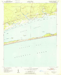 1951 Salter Path1951 Print · USGSCoastal life in the early fifties centers on the narrow strip of Bogue Banks and the mainland woods of the Croatan National Forest. Trace the origins of Salter Path or find old landings and landmarks like Yellow Hill Landing and Nine Foot Road.2 unique versions available
 - 1952 Map of Swansboro, 1954 Print
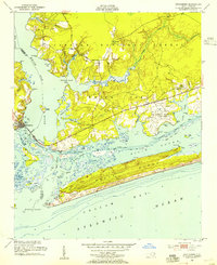 1952 Swansboro1954 Print · USGSCoastal North Carolina at the midpoint of the century reveals a landscape defined by its waterways and a growing military footprint. Genealogists and historians can trace family locations near Swansboro, locate the Bogue Sch, or study the layout of Bogue Airfield and the Coast Guard Station.4 unique versions available
 - 1953 Map of Beaufort, 1965 Print
 1953 Beaufort1965 Print · USGSThe North Carolina coastline in the mid-fifties reveals an era of massive military expansion alongside traditional maritime life. Genealogists can trace family names and small settlements from Sealevel to Sneads Ferry or locate landmarks like Fort Macon.3 unique versions available
 - 1954 Map of Beaufort
 1954 Beaufort1954 Print · USGSCoastal North Carolina in the mid-fifties reveals a landscape of strategic military installations, sprawling wetlands, and thriving rail towns. Genealogists and historians can trace the foundations of Wilmington, the rural reaches of Duplin County, and shoreline landmarks like Cape Lookout and Carolina Beach.
End of results
Showing maps 1-4 of 4
Top cities near Emerald Isle
- Havelock historical maps
- Morehead City historical maps
- Newport historical maps
- Swansboro historical maps
- Cape Carteret historical maps
- Atlantic Beach historical maps
See more
Top neighborhoods of Emerald Isle
- Pebble Beach historical maps
- Lands End historical maps
- Point Emerald Villas historical maps
- Sound of the Sea historical maps
- Queens Court historical maps
Frequently asked questions
- What are the different types of historical maps available for Emerald Isle?
- What is the oldest map of Emerald Isle?
- Where can I purchase historical maps of Emerald Isle for my home or office?
- Where can I download high-res historical maps of Emerald Isle?
- Are there historical topographic maps available for Emerald Isle?
- Is there historical aerial imagery available for Emerald Isle?
- Where are historical maps of Emerald Isle sourced from?