1940s Maps of Morehead City, North Carolina
Explore 3 historic maps of Morehead City from the 1940s. These maps offer a rare glimpse into what life looked like during the 1940s — showing old roads, neighborhoods, homes, and landmarks that have changed or disappeared over time.
Whether you're researching your family's past, planning a metal detecting trip, or studying how Morehead City's landscape evolved across the 1940s, these high-resolution maps are a powerful tool for exploring the history of this region.
- Focus on a specific era: All maps on this page are from the 1940s, giving you a focused view of this time period.
- See what’s changed: Compare century-old streets, trails, and buildings to today's modern landscape using overlays and satellite layers.
- Research with precision: Use these maps for genealogy, historical research, land use analysis, or educational projects.
- View, download, or print: Maps are fully viewable online in high resolution, and can be downloaded or printed for your own records.
Start exploring Morehead City's history through authentic maps from the 1940s. This is your window into the past.
Morehead City, NC maps
(3)- 1949 Map of Beaufort, 1964 Print
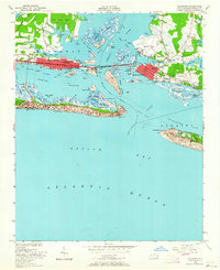 1949 Beaufort1964 Print · USGSCoastal Carteret County comes alive in the late 1940s, showing the developing waterfronts of Morehead City and Beaufort. Genealogists and historians can trace local landmarks like Bay View Cem, Fort Macon, and the Atlantic and East Carolina rail line.6 unique versions available
 - 1949 Map of Mansfield, 1984 Print
 1949 Mansfield1984 Print · USGSCoastal Carteret County comes alive in this mid-century survey as Morehead City and Mansfield grow alongside the Bogue Sound. Genealogists and historians can trace mainland landmarks like St Marks Chapel or early development on the banks at Atlantic Beach.
 - 1949 Map of Core Creek, 1984 Print
 1949 Core Creek1984 Print · USGSCoastal Carteret County is mapped here in the mid-twentieth century as the maritime and timber economies shaped the shoreline. Genealogists and local researchers can trace early homesteads and community life through Crab Point Village, Tattles Grove Ch, and the Barge Landing Basin.2 unique versions available
End of results
Showing maps 1-3 of 3
Top cities near Morehead City
- Havelock historical maps
- Newport historical maps
- Emerald Isle historical maps
- Atlantic Beach historical maps
- Pine Knoll Shores historical maps
- Indian Beach historical maps
Top neighborhoods of Morehead City
- Bonham Heights historical maps
- Mansfield historical maps
- Mitchell Village historical maps
- Carolina City historical maps
- Spooners Creek East Harbor historical maps
Frequently asked questions
- What are the different types of historical maps available for Morehead City?
- What is the oldest map of Morehead City?
- Where can I purchase historical maps of Morehead City for my home or office?
- Where can I download high-res historical maps of Morehead City?
- Are there historical topographic maps available for Morehead City?
- Is there historical aerial imagery available for Morehead City?
- Where are historical maps of Morehead City sourced from?