1990s Maps of Caswell County, North Carolina
Explore 4 historic maps of Caswell County from the 1990s. These maps offer a rare glimpse into what life looked like during the 1990s — showing old roads, neighborhoods, homes, and landmarks that have changed or disappeared over time.
Whether you're researching your family's past, planning a metal detecting trip, or studying how Caswell County's landscape evolved across the 1990s, these high-resolution maps are a powerful tool for exploring the history of this region.
- Focus on a specific era: All maps on this page are from the 1990s, giving you a focused view of this time period.
- See what’s changed: Compare century-old streets, trails, and buildings to today's modern landscape using overlays and satellite layers.
- Research with precision: Use these maps for genealogy, historical research, land use analysis, or educational projects.
- View, download, or print: Maps are fully viewable online in high resolution, and can be downloaded or printed for your own records.
Start exploring Caswell County's history through authentic maps from the 1990s. This is your window into the past.
Caswell County, NC maps
(4)- 1997 Map of Williamsburg, 2000 Print
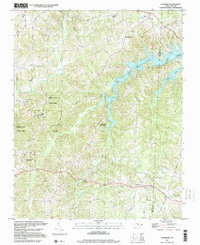
 1997 Williamsburg2000 Print · USGSThe Piedmont landscape of Rockingham and Caswell Counties in the late nineties is detailed here through its rural settlements and river networks. Genealogists can trace family landmarks like Settle Cem and Garrett Grove Ch along the Haw River.
 - 1997 Map of Milton, 2000 Print
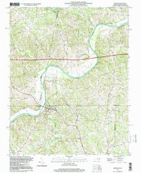 1997 Milton2000 Print · USGSThe North Carolina-Virginia borderlands are captured here in the late twentieth century, centered on the river town of Milton. Genealogists and local historians can trace rural landmarks from Sutherlin Millpond to numerous churches like Lebanon Ch and Calvary Ch.
 - 1997 Map of Cherry Grove, 2000 Print
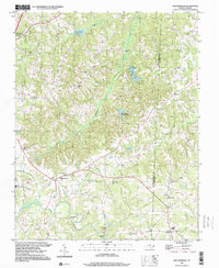
 1997 Cherry Grove2000 Print · USGSCaswell County in the late nineties is a landscape of established crossroads and managed wilderness. Researchers can map family-named landmarks and civic centers like Kerrs Chapel, the Stony Creek Sch, and the Cherokee Scout Reservation.
 - 1997 Map of Leasburg, 2000 Print
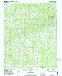
 1997 Leasburg2000 Print · USGSCaswell County in the late nineties retains its rural character, defined by the winding waters of Hyco Lake. Local historians can trace old community hubs like Leasburg and Red House, or locate landmarks such as Blanch Prison and Yarbro Mill.
End of results
Showing maps 1-4 of 4
Top cities of Caswell County
Frequently asked questions
- What are the different types of historical maps available for Caswell County?
- What is the oldest map of Caswell County?
- Where can I purchase historical maps of Caswell County for my home or office?
- Where can I download high-res historical maps of Caswell County?
- Are there historical topographic maps available for Caswell County?
- Is there historical aerial imagery available for Caswell County?
- Where are historical maps of Caswell County sourced from?