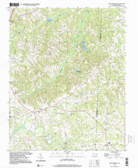
1997 Map of Williamsburg
USGS Topo · Published 2000About this map
Williamsburg serves as a central hub in this section of the Piedmont, where the rural landscape is defined by the headwaters of the Haw River and numerous winding tributaries. The map documents a significant concentration of local landmarks, from the Williamsburg Sch to a network of country churches including Thompsonville Ch and Grooms Chapel. The area’s historical depth is evident in its small cemeteries, such as the Lawsonville Road Cem and Settle Cem, which reflect the generations of families that settled this land. Settlement patterns follow the ridgelines and creek valleys, with smaller communities like Ashland and Matkins connected by a web of local roads. Water resources are prominent throughout the quadrangle, featuring both natural drainage like Jones Creek and Hogans Creek, and man-made bodies such as Lake Wade and Williamsburg Wildlife Lake.
Find a feature on this map
32 named features on this map. Tap any name to fly to it.
Don’t see what you’re looking for? This feature index may not catch every label — zoom into the map to look around manually.
Map Details
Editions of this 1997 Williamsburg Map
This is the sole edition of this map. No revisions or reprints were ever made.
Other maps of this area

1951 · Browns Summit
USGS Topo · 1:24,000

1953 · Greensboro
USGS Topo · 1:250,000

1954 · Greensboro
USGS Topo · 1:250,000

1962 · Greensboro
USGS Topo · 1:250,000

1966 · Greensboro
USGS Topo · 1:250,000

1969 · Lake Burlington
USGS Topo · 1:24,000

1970 · Ossipee
USGS Topo · 1:24,000
1971 · Southeast Eden
USGS Topo · 1:24,000
1971 · Ruffin
USGS Topo · 1:24,000
1972 · Williamsburg
USGS Topo · 1:24,000