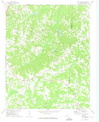
1972 Map of Williamsburg
USGS Topo · Published 1974About this map
Williamsburg serves as a central hub in this rural landscape along the Rockingham Co Caswell Co line during the early 1970s. The settlement pattern is defined by a dense network of country churches and family-linked landmarks, such as Settle Ch and its adjacent Settle Cem. These spiritual and social centers are scattered across the terrain, including Browns Chapel, Grooms Chapel, and Lawsonville Road Ch, reflecting the deep-rooted community ties of the era.
Find a feature on this map
33 named features on this map. Tap any name to fly to it.
Don’t see what you’re looking for? This feature index may not catch every label — zoom into the map to look around manually.
Map Details
Editions of this 1972 Williamsburg Map
This is the sole edition of this map. No revisions or reprints were ever made.
Other maps of this area

1951 · Browns Summit
USGS Topo · 1:24,000

1953 · Greensboro
USGS Topo · 1:250,000

1954 · Greensboro
USGS Topo · 1:250,000

1962 · Greensboro
USGS Topo · 1:250,000

1966 · Greensboro
USGS Topo · 1:250,000

1969 · Lake Burlington
USGS Topo · 1:24,000

1970 · Ossipee
USGS Topo · 1:24,000
1971 · Southeast Eden
USGS Topo · 1:24,000
1971 · Ruffin
USGS Topo · 1:24,000
1972 · Park Spring
USGS Topo · 1:24,000