1930s Maps of Boiling Springs, North Carolina
Explore 3 historic maps of Boiling Springs from the 1930s. These maps offer a rare glimpse into what life looked like during the 1930s — showing old roads, neighborhoods, homes, and landmarks that have changed or disappeared over time.
Whether you're researching your family's past, planning a metal detecting trip, or studying how Boiling Springs's landscape evolved across the 1930s, these high-resolution maps are a powerful tool for exploring the history of this region.
- Focus on a specific era: All maps on this page are from the 1930s, giving you a focused view of this time period.
- See what’s changed: Compare century-old streets, trails, and buildings to today's modern landscape using overlays and satellite layers.
- Research with precision: Use these maps for genealogy, historical research, land use analysis, or educational projects.
- View, download, or print: Maps are fully viewable online in high resolution, and can be downloaded or printed for your own records.
Start exploring Boiling Springs's history through authentic maps from the 1930s. This is your window into the past.
Boiling Springs, NC maps
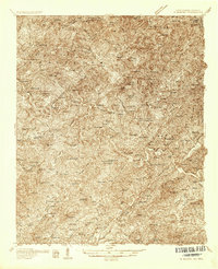
(3)- 1934 Map of McDaniel Bald
 1934 McDaniel Bald1934 Print · USGSThe North Carolina and Tennessee borderlands appear here in the mid-1930s, showing a network of high-elevation gaps and remote mountain schools. Genealogists can locate family landmarks like Bryson Cem, Ebenezer, and schools including Owl Creek Sch and Davis Creek Sch.
 - 1934 Map of Murphy
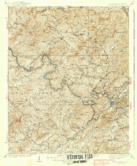
 1934 Murphy1934 Print · USGSWestern North Carolina during the mid-thirties reveals a mountain landscape transitioning from resource extraction to managed forest. Researchers can trace family roots at Old Friendship Cem or locate industrial sites like Culberson Mine and Regal Sta.
 - 1938 Map of Fowler Bend
 1938 Fowler Bend1938 Print · USGSThe mountain landscape of Cherokee County is captured in the mid-1930s, just as the Nottely Dam began reshaping the river valleys. Local historians can trace early community hubs like Dockery Store, the L & N RR, and the Henson Donation Indian Reservation.2 unique versions available
End of results
Showing maps 1-3 of 3
Top cities near Boiling Springs
- Andrews historical maps
- Murphy historical maps
- Robbinsville historical maps
- Hayesville historical maps
- Lake Santeetlah historical maps
- Fontana Dam historical maps
Frequently asked questions
- What are the different types of historical maps available for Boiling Springs?
- What is the oldest map of Boiling Springs?
- Where can I purchase historical maps of Boiling Springs for my home or office?
- Where can I download high-res historical maps of Boiling Springs?
- Are there historical topographic maps available for Boiling Springs?
- Is there historical aerial imagery available for Boiling Springs?
- Where are historical maps of Boiling Springs sourced from?