1900s (20th Century) Maps of Cherokee County Community, North Carolina
Explore 25 historic maps of Cherokee County Community from the 1900s (20th Century). These maps offer a rare glimpse into what life looked like during the 1900s — showing old roads, neighborhoods, homes, and landmarks that have changed or disappeared over time.
Whether you're researching your family's past, planning a metal detecting trip, or studying how Cherokee County Community's landscape evolved across the 1900s, these high-resolution maps are a powerful tool for exploring the history of this region.
- Focus on a specific era: All maps on this page are from the 1900s, giving you a focused view of this time period.
- See what’s changed: Compare century-old streets, trails, and buildings to today's modern landscape using overlays and satellite layers.
- Research with precision: Use these maps for genealogy, historical research, land use analysis, or educational projects.
- View, download, or print: Maps are fully viewable online in high resolution, and can be downloaded or printed for your own records.
Start exploring Cherokee County Community's history through authentic maps from the 1900s. This is your window into the past.
Cherokee County Community, NC maps
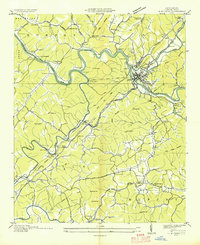
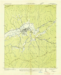
(25)- 1914 Map of Murphy
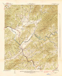
 1914 Murphy1914 Print · USGSThe Tennessee-North Carolina borderlands come to life in this early twentieth-century survey, showcasing a landscape of mountain ridges and river-driven commerce. Researchers can trace the Louisville and Nashville Railroad to old stops like Apalachia Sta or locate the historic Prince Ferry and White Cliff Springs.3 unique versions available
 - 1934 Map of Murphy
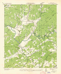
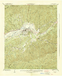
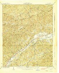
 1934 Murphy1934 Print · USGSCherokee County at the height of the mid-thirties TVA era reveals a landscape shaped by river junctions and dual rail lines. Genealogists and local historians can trace rural family life through landmarks like Rogers Chapel, Martin Creek Sch, and the industrial activity at the Talc Mine.
 - 1934 Map of McDaniel Bald
 1934 McDaniel Bald1934 Print · USGSThe North Carolina and Tennessee borderlands appear here in the mid-1930s, showing a network of high-elevation gaps and remote mountain schools. Genealogists can locate family landmarks like Bryson Cem, Ebenezer, and schools including Owl Creek Sch and Davis Creek Sch.
 - 1934 Map of Murphy
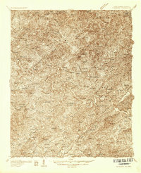 1934 Murphy1934 Print · USGSWestern North Carolina during the mid-thirties reveals a mountain landscape transitioning from resource extraction to managed forest. Researchers can trace family roots at Old Friendship Cem or locate industrial sites like Culberson Mine and Regal Sta.
 - 1935 Map of Peachtree
 1935 Peachtree1935 Print · USGSCherokee and Clay counties appear here in the mid-1930s, showing the mountain communities along the Hiwassee River. Genealogists and historians can locate the John C Campbell Folk Sch, Sally Nebo Ch, and the site of Andrews Dam.
 - 1935 Map of Marble
 1935 Marble1935 Print · USGSCherokee County enters a period of industrial growth in the mid-1930s as the Valley River becomes a corridor for rail and mining. Researchers can trace the heritage of Marble, locate the Talc Mine, and find family sites like Moss Cem or Oak Grove Sch.
 - 1935 Map of Andrews
 1935 Andrews1935 Print · USGSMid-1930s Cherokee County centers on the rail-driven town of Andrews as it sits between the Snowbird Mountains and Tusquitee Mountains. Genealogists and historians can trace local landmarks like Valleytown Cem, the Junaluska Sch, and the unique Valley River Tunnel.
 - 1937 Map of Peachtree, 1957 Print
 1937 Peachtree1957 Print · USGSWestern North Carolina's river valleys and mountain ridges are captured in the late 1930s as agricultural life centered around Brasstown and Peachtree. Researchers can locate historic rural sites like the Campbell Folk School, Jones Mill, and Wells Cem.4 unique versions available
 - 1938 Map of Andrews
 1938 Andrews1938 Print · USGSWestern North Carolina mountain life is centered on the Andrews valley in the late thirties as the Southern railroad connects these high peaks. Genealogists and hikers can trace old routes through Granny Squirrel Gap, locate the Valleytown Cem, or find the State Prison Camp.7 unique versions available
 - 1938 Map of Fowler Bend
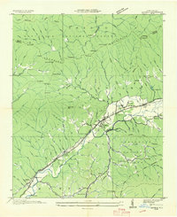
 1938 Fowler Bend1938 Print · USGSThe mountain landscape of Cherokee County is captured in the mid-1930s, just as the Nottely Dam began reshaping the river valleys. Local historians can trace early community hubs like Dockery Store, the L & N RR, and the Henson Donation Indian Reservation.2 unique versions available
 - 1938 Map of Peachtree
 1938 Peachtree1938 Print · USGSCherokee and Clay Counties are shown here in the late thirties, a period when rural electrification projects began to intersect with traditional mountain communities. Genealogists can locate family landmarks like the Campbell Folk School, Wells Cem, and many local congregations including Mission Ch.
 - 1938 Map of Marble
 1938 Marble1938 Print · USGSWestern North Carolina’s mountain valleys are captured here in the late 1930s as the rail-and-river economy centered on Marble thrived. Researchers can locate early schools and churches like Slow Creek Sch and Fairview Ch, alongside industrial markers like Terrazzo Switch.6 unique versions available
 - 1953 Map of Chattanooga
 1953 Chattanooga1953 Print · USGSSoutheast Tennessee in the early fifties shows a landscape reshaped by river management and rail power. Trace the rail lines of the Southern Ry through riverside towns or locate the preserved grounds of the Chickamauga and Chattanooga National Military Park.
 - 1955 Map of Knoxville
 1955 Knoxville1955 Print · USGSThe Southern Appalachians and the Smoky Mountains are shown here at a peak of mid-century development and conservation. Genealogists and historians can trace the early road networks connecting Gatlinburg, Waynesville, and the Cherokee Indian Reservation across the high ridges.
 - 1957 Map of Mc Daniel Bald, 1958 Print
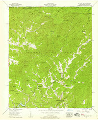 1957 Mc Daniel Bald1958 Print · USGSCherokee County’s high ridges and national forest lands are captured in the late fifties as the Joe Brown Highway connected remote valley settlements. Researchers can trace family roots at Bryson Cemetery or locate old community centers like Grandview and White Church School.3 unique versions available
 - 1957 Map of Murphy, 1958 Print
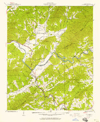
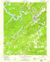 1957 Murphy1958 Print · USGSMurphy and the rugged Nottely River valley are captured in the late fifties, showing the interplay of forest land and river commerce. Genealogists and historians can locate family cemeteries like Old Martins Creek Cem, local institutions such as Murphy High Sch, and the historical bounds of the Cherokee Indian Land Donation.4 unique versions available
 - 1957 Map of Knoxville, 1966 Print
 1957 Knoxville1966 Print · USGSThe Southern Appalachians of Tennessee and North Carolina are mapped here during the mid-twentieth century as new highways reached the high country. Genealogists and historians can trace the topography between Knoxville and Asheville, locating family landmarks near Fontana Lake or along the Blue Ridge Parkway.4 unique versions available
 - 1957 Map of Chattanooga, 1966 Print
 1957 Chattanooga1966 Print · USGSEast Tennessee in the mid-1960s shows a landscape of massive hydroelectric reservoirs and emerging industrial sites like the Atomic Energy Commission (Oak Ridge Area). Trace the rail networks of the Southern Ry through Chattanooga or locate family-named ridges across the Cumberland Plateau.3 unique versions available
 - 1959 Map of Chattanooga
 1959 Chattanooga1959 Print · USGSSoutheast Tennessee is shown here during a decade of industrial growth and hydroelectric development. Trace the regional rail networks of the Southern Ry and find landmark sites like Lookout Mountain, Fall Creek Falls State Park, and Chattanooga.
 - 1960 Map of Knoxville
 1960 Knoxville1960 Print · USGSThe Southern Appalachians come alive in the 1950s, showing the intersection of new national park tourism and deep-rooted mountain industry. Trace old rail lines like the Clinchfield RR and find high-altitude landmarks from Mt Le Conte to the Cherokee Indian Reservation.2 unique versions available
 - 1960 Map of Chattanooga
 1960 Chattanooga1960 Print · USGSSoutheast Tennessee and the southern Appalachians are shown here at the height of the river-management era. You can trace the valley rail lines and locate Lookout Mountain and the expansive waters of Chickamauga Reservoir.
 - 1964 Map of Chattanooga
 1964 Chattanooga1964 Print · USGSSoutheast Tennessee and the western Carolinas appear in the mid-sixties as a powerhouse of river-driven industry and mountain wilderness. Genealogists and historians can trace rail-town lineages along the Southern Ry or locate family landmarks near Watts Bar Lake and Tellico Plains.
 - 1964 Map of Knoxville
 1964 Knoxville1964 Print · USGSThe Southern Appalachians and Great Smokies are captured here during the mid-sixties, showing the rugged borderlands of Tennessee and North Carolina. Researchers can trace historic mountain routes like U S 441, the expanse of Pisgah National Forest, and the growing footprints of Asheville and Knoxville.
 - 1981 Map of Cleveland
 1981 Cleveland1981 Print · USGSSoutheast Tennessee and Western North Carolina are documented here in the early eighties, as the Tennessee Valley Authority managed the region's vast river and forest resources. Researchers can trace the rail lines of the Southern and Louisville and Nashville or locate industrial sites in the Copper Basin and settlements like Ducktown.2 unique versions available
 - 1983 Map of Fontana Lake
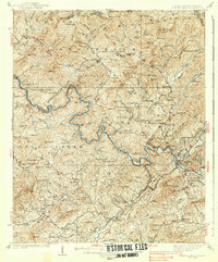
 1983 Fontana Lake1983 Print · USGSWestern North Carolina's high peaks and reservoir-carved valleys are documented here during the early eighties. Genealogists and local historians can trace the mountain communities of Bryson City and Franklin or explore the boundaries of the Qualla Boundary.2 unique versions available
End of results
Showing maps 1-25 of 25
Top cities near Cherokee County Community
- Andrews historical maps
- Murphy historical maps
- Hiawassee historical maps
- Robbinsville historical maps
- Young Harris historical maps
- Hayesville historical maps
See more
Top neighborhoods of Cherokee County Community
Frequently asked questions
- What are the different types of historical maps available for Cherokee County Community?
- What is the oldest map of Cherokee County Community?
- Where can I purchase historical maps of Cherokee County Community for my home or office?
- Where can I download high-res historical maps of Cherokee County Community?
- Are there historical topographic maps available for Cherokee County Community?
- Is there historical aerial imagery available for Cherokee County Community?
- Where are historical maps of Cherokee County Community sourced from?