1900s (20th Century) Maps of Mavaton, North Carolina
Explore 7 historic maps of Mavaton from the 1900s (20th Century). These maps offer a rare glimpse into what life looked like during the 1900s — showing old roads, neighborhoods, homes, and landmarks that have changed or disappeared over time.
Whether you're researching your family's past, planning a metal detecting trip, or studying how Mavaton's landscape evolved across the 1900s, these high-resolution maps are a powerful tool for exploring the history of this region.
- Focus on a specific era: All maps on this page are from the 1900s, giving you a focused view of this time period.
- See what’s changed: Compare century-old streets, trails, and buildings to today's modern landscape using overlays and satellite layers.
- Research with precision: Use these maps for genealogy, historical research, land use analysis, or educational projects.
- View, download, or print: Maps are fully viewable online in high resolution, and can be downloaded or printed for your own records.
Start exploring Mavaton's history through authentic maps from the 1900s. This is your window into the past.
Mavaton, NC maps
(7)- 1904 Map of Edenton
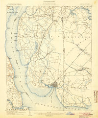 1904 Edenton1904 Print · USGSThe Chowan River and Albemarle Sound waterfronts are documented here at the turn of the century. Genealogists and historians can trace defunct river landings like Jernigens Wharf and old postal hubs such as Mege P.O. and Tynes P.O. Center Hill.2 unique versions available
 - 1942 Map of Edenton
 1942 Edenton1942 Print · USGSThe Albemarle Sound and Chowan River shoreline appear here during the Second World War as both a military hub and a quiet riverfront. Researchers can trace historic river landings like Mt Gould Landing alongside the sprawling U S Marine Corps Air Station and the Norfolk Southern RR.
 - 1943 Map of Edenton
 1943 Edenton1943 Print · USGSCoastal North Carolina during the early years of the war shows a landscape of strategic military sites and traditional river landings. Genealogists can trace family roots through St. Johns church or explore the rail-and-water economy at Edenton and Hermitage Wharf.
 - 1953 Map of Norfolk, 1954 Print
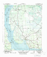
 1953 Norfolk1954 Print · USGSCoastal Virginia and northeastern North Carolina appear here during the post-war industrial boom, showing the critical rail-and-sea connections of Hampton Roads. Genealogists can trace family roots through rural landmarks like Gethsemane Ch, the Caledonia State Prison Farm, and the vast interior of the Dismal Swamp.4 unique versions available
 - 1982 Map of Valhalla
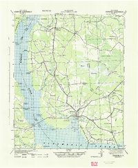
 1982 Valhalla1982 Print · USGSThe Chowan River shoreline and the rural crossroads of eastern North Carolina come alive in this early 1980s survey. Genealogists and local historians can trace family roots through landmarks like Chowan Academy, White Oak Ch, and Dillard Millpond.
 - 1985 Map of Elizabeth City
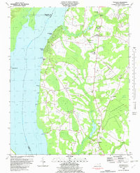
 1985 Elizabeth City1985 Print · USGSCoastal North Carolina's rivers and sounds define the landscape of the mid-eighties, from the vast swamps to the historical waterfronts of Elizabeth City and Edenton. Researchers can trace the rail lines of the Southern Ry or locate landmarks like Beaver Hill Cem and South Mills.2 unique versions available
 - 1997 Map of Valhalla, 2000 Print
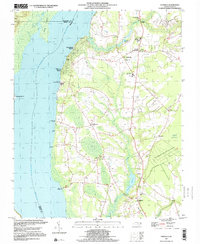 1997 Valhalla2000 Print · USGSThe Chowan River shoreline and the swampy interiors of Chowan County are captured here in the late nineties. Local researchers can trace family roots through numerous sites like Chowan Academy, Rockyhock Ch, and the many rural cemeteries scattered near Valhalla.
End of results
Showing maps 1-7 of 7
Top cities near Mavaton
- Edenton historical maps
- Hertford historical maps
- Arrowhead Beach historical maps
- Winfall historical maps
- Gatesville historical maps
- Colerain historical maps
See more
Frequently asked questions
- What are the different types of historical maps available for Mavaton?
- What is the oldest map of Mavaton?
- Where can I purchase historical maps of Mavaton for my home or office?
- Where can I download high-res historical maps of Mavaton?
- Are there historical topographic maps available for Mavaton?
- Is there historical aerial imagery available for Mavaton?
- Where are historical maps of Mavaton sourced from?