
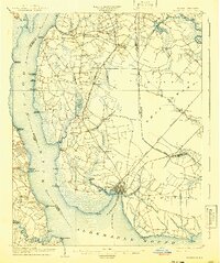
1904 Map of Edenton
USGS Topo · Published 1904About this map
Edenton serves as the focal point of this 1902 survey, situated at the confluence of the Chowan River, Edenton Bay, and the Albemarle Sound. The map reveals an intricate network of early 20th-century transportation, characterized by numerous river landings such as Mt. Gould Landing and Emperor Landing, which were vital for regional commerce before modern road systems. Inland, the presence of the Virginia and Carolina Southern RR and a Narrow Gauge tramroad indicate a landscape driven by timber and agricultural transport.
Find a feature on this map
75 named features on this map. Tap any name to fly to it.
Don’t see what you’re looking for? This feature index may not catch every label — zoom into the map to look around manually.
Map Details
Editions of this 1904 Edenton Map
2 editions found
Other maps of this area

1906 · Hertford
USGS Topo · 1:62,500

1906 · Beckford
USGS Topo · 1:48,000

1907 · Beckford
USGS Topo · 1:62,500

1908 · Winton
USGS Topo · 1:62,500

1940 · Hertford
USGS Topo · 1:62,500

1940 · Beckford
USGS Topo · 1:62,500

1940 · South Mills
USGS Topo · 1:62,500

1942 · Edenton
USGS Topo · 1:62,500

1943 · Columbia
USGS Topo · 1:125,000

1943 · Plymouth
USGS Topo · 1:125,000