1930s Maps of Elf, North Carolina
Explore 2 historic maps of Elf from the 1930s. These maps offer a rare glimpse into what life looked like during the 1930s — showing old roads, neighborhoods, homes, and landmarks that have changed or disappeared over time.
Whether you're researching your family's past, planning a metal detecting trip, or studying how Elf's landscape evolved across the 1930s, these high-resolution maps are a powerful tool for exploring the history of this region.
- Focus on a specific era: All maps on this page are from the 1930s, giving you a focused view of this time period.
- See what’s changed: Compare century-old streets, trails, and buildings to today's modern landscape using overlays and satellite layers.
- Research with precision: Use these maps for genealogy, historical research, land use analysis, or educational projects.
- View, download, or print: Maps are fully viewable online in high resolution, and can be downloaded or printed for your own records.
Start exploring Elf's history through authentic maps from the 1930s. This is your window into the past.
Elf, NC maps
(2)- 1935 Map of Shooting Creek
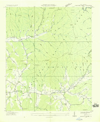 1935 Shooting Creek1935 Print · USGSClay County mountain life is recorded in this mid-1930s survey of the high ridges and deep coves. Genealogists can locate family landmarks like Tidwell Sch, Marshall Chapel, and the community at Tusquitee long before modern road improvements.
 - 1935 Map of Wayah Bald
 1935 Wayah Bald1935 Print · USGSHigh in the Blue Ridge Mountains during the mid-1930s, this survey reveals the isolated homesteads and forest tracts of Macon County. Genealogists can locate family landmarks like Marshall Chapel, Oakdale Sch, and the remote Kyle PO or Flats PO.
End of results
Showing maps 1-2 of 2
Top cities near Elf
- Andrews historical maps
- Hiawassee historical maps
- Blairsville historical maps
- Young Harris historical maps
- Hayesville historical maps
Frequently asked questions
- What are the different types of historical maps available for Elf?
- What is the oldest map of Elf?
- Where can I purchase historical maps of Elf for my home or office?
- Where can I download high-res historical maps of Elf?
- Are there historical topographic maps available for Elf?
- Is there historical aerial imagery available for Elf?
- Where are historical maps of Elf sourced from?