1935 Map of Shooting Creek
USGS Topo · Published 1935About this map
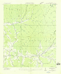
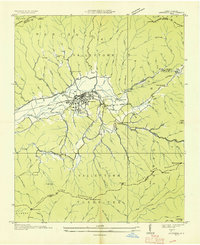
Tusquitee and the scattered mountain settlements of western North Carolina appear here during a mid-1930s survey conducted by the Tennessee Valley Authority. The landscape is dominated by the steep ridges of the Nantahala National Forest, where life centered around small communities and subsistence features like the unnamed Mine and the Shooting Creek Vineyard. The settlement pattern follows the narrow valley floors, primarily along Shooting Creek and Tusquitee Creek, where rural institutions served the mountain families.
Find a feature on this map
106 named features on this map. Tap any name to fly to it.
Don’t see what you’re looking for? This feature index may not catch every label — zoom into the map to look around manually.
Map Details
Editions of this 1935 Shooting Creek Map
This is the sole edition of this map. No revisions or reprints were ever made.
Other maps of this area

1886 · Dahlonega
USGS Topo · 1:125,000

1892 · Dahlonega
USGS Topo · 1:125,000

1896 · Dahlonega
USGS Topo · 1:125,000

1903 · Dahlonega
USGS Topo · 1:125,000

1935 · Osborn
USGS Topo · 1:24,000

1935 · Rainbow Springs
USGS Topo · 1:24,000

1935 · Burningtown Bald
USGS Topo · 1:24,000

1935 · Topton
USGS Topo · 1:24,000

1935 · Wayah Bald
USGS Topo · 1:48,000
1935 · Andrews
USGS Topo · 1:24,000