1970s Maps of Elizabeth City, Shelby
Explore 2 historic maps of Elizabeth City from the 1970s. These maps offer a rare glimpse into what life looked like during the 1970s — showing old roads, neighborhoods, homes, and landmarks that have changed or disappeared over time.
Whether you're researching your family's past, planning a metal detecting trip, or studying how Elizabeth City's landscape evolved across the 1970s, these high-resolution maps are a powerful tool for exploring the history of this region.
- Focus on a specific era: All maps on this page are from the 1970s, giving you a focused view of this time period.
- See what’s changed: Compare century-old streets, trails, and buildings to today's modern landscape using overlays and satellite layers.
- Research with precision: Use these maps for genealogy, historical research, land use analysis, or educational projects.
- View, download, or print: Maps are fully viewable online in high resolution, and can be downloaded or printed for your own records.
Start exploring Elizabeth City's history through authentic maps from the 1970s. This is your window into the past.
Elizabeth City, Shelby maps
(2)- 1973 Map of Waco, 1976 Print
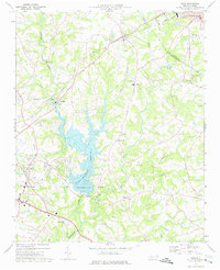 1973 Waco1976 Print · USGSCleveland County and the Gaston County border are captured here in the early seventies as the local landscape transitioned toward modern recreation and industry. Researchers can find numerous country landmarks like Washington Sch, Hullender Cem, and the Seaboard Coast Line railroad.
 - 1976 Map of Waco, 1978 Print
 1976 Waco1978 Print · USGSCleveland County lands and the nascent shoreline of Kings Mountain Reservoir appear in this mid-seventies aerial survey. Researchers can trace the exact footprint of farms and woodlots surrounding Waco, Stubbs, and Oak Grove.
End of results
Showing maps 1-2 of 2
Top cities near Elizabeth City
- Gastonia historical maps
- Shelby historical maps
- Gaffney historical maps
- Lincolnton historical maps
- Kings Mountain historical maps
- Cherryville historical maps
See more
Frequently asked questions
- What are the different types of historical maps available for Elizabeth City?
- What is the oldest map of Elizabeth City?
- Where can I purchase historical maps of Elizabeth City for my home or office?
- Where can I download high-res historical maps of Elizabeth City?
- Are there historical topographic maps available for Elizabeth City?
- Is there historical aerial imagery available for Elizabeth City?
- Where are historical maps of Elizabeth City sourced from?