1980s Maps of Bolton, North Carolina
Explore 3 historic maps of Bolton from the 1980s. These maps offer a rare glimpse into what life looked like during the 1980s — showing old roads, neighborhoods, homes, and landmarks that have changed or disappeared over time.
Whether you're researching your family's past, planning a metal detecting trip, or studying how Bolton's landscape evolved across the 1980s, these high-resolution maps are a powerful tool for exploring the history of this region.
- Focus on a specific era: All maps on this page are from the 1980s, giving you a focused view of this time period.
- See what’s changed: Compare century-old streets, trails, and buildings to today's modern landscape using overlays and satellite layers.
- Research with precision: Use these maps for genealogy, historical research, land use analysis, or educational projects.
- View, download, or print: Maps are fully viewable online in high resolution, and can be downloaded or printed for your own records.
Start exploring Bolton's history through authentic maps from the 1980s. This is your window into the past.
Bolton, NC maps
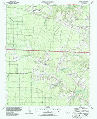
(3)- 1986 Map of Lake Waccamaw East
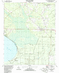 1986 Lake Waccamaw East1986 Print · USGSCoastal plain wetlands and small-town rail corridors define this mid-1980s look at Columbus County. Researchers can trace the Seaboard System tracks through Bolton and locate family landmarks like Union Chapel and Goose Hollow.
 - 1986 Map of Freeman
 1986 Freeman1986 Print · USGSSoutheastern North Carolina in the mid-1980s reveals a landscape of rural communities and railroad corridors along the Bladen and Columbus county line. Genealogists can trace family footprints through numerous country churches and cemeteries near Byrdville, Freeman, and East Arcadia.
 - 1986 Map of Whiteville
 1986 Whiteville1986 Print · USGSSoutheastern North Carolina and the South Carolina borderlands are captured here in the mid-1980s as a landscape of vast swamps and rail towns. Researchers can trace historic rail routes through Chadbourn, locate the namesake Lake Waccamaw, and explore family-named sites like Peacocks.
End of results
Showing maps 1-3 of 3
Top cities near Bolton
- Lake Waccamaw historical maps
- Northwest historical maps
- East Arcadia historical maps
- Sandyfield historical maps
- Atkinson historical maps
- Sandy Creek historical maps
Frequently asked questions
- What are the different types of historical maps available for Bolton?
- What is the oldest map of Bolton?
- Where can I purchase historical maps of Bolton for my home or office?
- Where can I download high-res historical maps of Bolton?
- Are there historical topographic maps available for Bolton?
- Is there historical aerial imagery available for Bolton?
- Where are historical maps of Bolton sourced from?