1950s Maps of Havelock, North Carolina
Explore 5 historic maps of Havelock from the 1950s. These maps offer a rare glimpse into what life looked like during the 1950s — showing old roads, neighborhoods, homes, and landmarks that have changed or disappeared over time.
Whether you're researching your family's past, planning a metal detecting trip, or studying how Havelock's landscape evolved across the 1950s, these high-resolution maps are a powerful tool for exploring the history of this region.
- Focus on a specific era: All maps on this page are from the 1950s, giving you a focused view of this time period.
- See what’s changed: Compare century-old streets, trails, and buildings to today's modern landscape using overlays and satellite layers.
- Research with precision: Use these maps for genealogy, historical research, land use analysis, or educational projects.
- View, download, or print: Maps are fully viewable online in high resolution, and can be downloaded or printed for your own records.
Start exploring Havelock's history through authentic maps from the 1950s. This is your window into the past.
Havelock, NC maps
(5)- 1951 Map of Newport
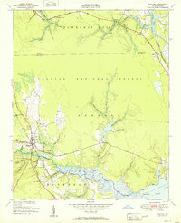 1951 Newport1951 Print · USGSCoastal North Carolina during the early fifties reveals a landscape of tidal rivers and timberlands within the Croatan National Forest. Researchers can trace old family sites and local landmarks like Hymans Chapel, the Prison Camp, and the historic rail line at Newport.3 unique versions available
 - 1951 Map of Cherry Point
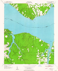 1951 Cherry Point1951 Print · USGSCoastal Craven County comes alive in the early fifties as military installations and riverfront camps began to define the Neuse River shoreline. Genealogists and historians can trace the footprint of the US Marine Corps Air Station Cherry Point or locate local landmarks like Weeping Mary Ch and Minnesott Beach.2 unique versions available
 - 1951 Map of Masontown
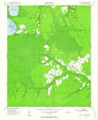 1951 Masontown1951 Print · USGSCoastal North Carolina during the early 1950s reveals a landscape of managed wetlands and isolated settlements within the Croatan National Forest. Local historians can trace old transit routes like the Nine Foot Road and locate rural communities at Masontown and Holly Springs.3 unique versions available
 - 1953 Map of Beaufort, 1965 Print
 1953 Beaufort1965 Print · USGSThe North Carolina coastline in the mid-fifties reveals an era of massive military expansion alongside traditional maritime life. Genealogists can trace family names and small settlements from Sealevel to Sneads Ferry or locate landmarks like Fort Macon.3 unique versions available
 - 1954 Map of Beaufort
 1954 Beaufort1954 Print · USGSCoastal North Carolina in the mid-fifties reveals a landscape of strategic military installations, sprawling wetlands, and thriving rail towns. Genealogists and historians can trace the foundations of Wilmington, the rural reaches of Duplin County, and shoreline landmarks like Cape Lookout and Carolina Beach.
End of results
Showing maps 1-5 of 5
Top cities near Havelock
- New Bern historical maps
- Morehead City historical maps
- James City historical maps
- Newport historical maps
- Trent Woods historical maps
- Emerald Isle historical maps
See more
Top neighborhoods of Havelock
- Slocum Village historical maps
- Wolf Creek historical maps
- College Park historical maps
- Manteo historical maps
- Jerrett Estates historical maps
- Havelock Station historical maps
See more
Frequently asked questions
- What are the different types of historical maps available for Havelock?
- What is the oldest map of Havelock?
- Where can I purchase historical maps of Havelock for my home or office?
- Where can I download high-res historical maps of Havelock?
- Are there historical topographic maps available for Havelock?
- Is there historical aerial imagery available for Havelock?
- Where are historical maps of Havelock sourced from?