1990s Maps of Eastover, North Carolina
Explore 3 historic maps of Eastover from the 1990s. These maps offer a rare glimpse into what life looked like during the 1990s — showing old roads, neighborhoods, homes, and landmarks that have changed or disappeared over time.
Whether you're researching your family's past, planning a metal detecting trip, or studying how Eastover's landscape evolved across the 1990s, these high-resolution maps are a powerful tool for exploring the history of this region.
- Focus on a specific era: All maps on this page are from the 1990s, giving you a focused view of this time period.
- See what’s changed: Compare century-old streets, trails, and buildings to today's modern landscape using overlays and satellite layers.
- Research with precision: Use these maps for genealogy, historical research, land use analysis, or educational projects.
- View, download, or print: Maps are fully viewable online in high resolution, and can be downloaded or printed for your own records.
Start exploring Eastover's history through authentic maps from the 1990s. This is your window into the past.
Eastover, NC maps
(3)- 1997 Map of Stedman, 2000 Print
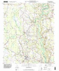 1997 Stedman2000 Print · USGSCoastal plain settlements east of Fayetteville thrived amidst the wetlands and creeks of the North Carolina interior in the late nineties. Researchers can trace family history through numerous landmarks like China Grove Ch, Fisher Cem, and the rural crossroads of Stedman.
 - 1997 Map of Vander, 2000 Print
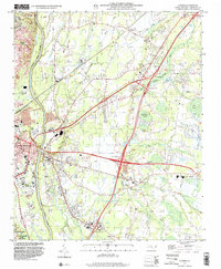 1997 Vander2000 Print · USGSThe eastern outskirts of Fayetteville and the community of Vander are shown in the late 1990s as modern highway interchanges began to reshape the landscape. Local historians can trace established landmarks like Cape Fear High School, St Lukes Ch, and the many cemeteries dotting the rural areas of Eastover and Beard.
 - 1997 Map of Slocomb, 2000 Print
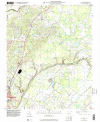 1997 Slocomb2000 Print · USGSCumberland County sits at a geographic crossroads in the late nineties as the outskirts of North Carolina's growing hubs meet the river. Researchers can trace rural landmarks including Long Hill Sch, the Race Track, and the small settlement of Slocomb.
End of results
Showing maps 1-3 of 3
Top cities near Eastover
- Fayetteville historical maps
- Hope Mills historical maps
- Dunn historical maps
- Spring Lake historical maps
- Erwin historical maps
- Stedman historical maps
See more
Top neighborhoods of Eastover
Frequently asked questions
- What are the different types of historical maps available for Eastover?
- What is the oldest map of Eastover?
- Where can I purchase historical maps of Eastover for my home or office?
- Where can I download high-res historical maps of Eastover?
- Are there historical topographic maps available for Eastover?
- Is there historical aerial imagery available for Eastover?
- Where are historical maps of Eastover sourced from?