1970s Maps of Fayetteville, North Carolina
Explore 7 historic maps of Fayetteville from the 1970s. These maps offer a rare glimpse into what life looked like during the 1970s — showing old roads, neighborhoods, homes, and landmarks that have changed or disappeared over time.
Whether you're researching your family's past, planning a metal detecting trip, or studying how Fayetteville's landscape evolved across the 1970s, these high-resolution maps are a powerful tool for exploring the history of this region.
- Focus on a specific era: All maps on this page are from the 1970s, giving you a focused view of this time period.
- See what’s changed: Compare century-old streets, trails, and buildings to today's modern landscape using overlays and satellite layers.
- Research with precision: Use these maps for genealogy, historical research, land use analysis, or educational projects.
- View, download, or print: Maps are fully viewable online in high resolution, and can be downloaded or printed for your own records.
Start exploring Fayetteville's history through authentic maps from the 1970s. This is your window into the past.
Fayetteville, NC maps
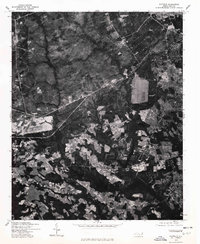
(7)- 1972 Map of Parkton, 1976 Print
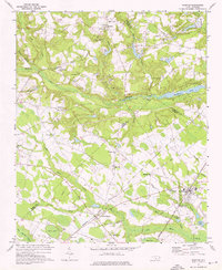 1972 Parkton1976 Print · USGSParkton and the surrounding North Carolina swamps are captured in the early 1970s as the regional rail network still tied together rural communities. Researchers can trace family history through sites like Pittman Grove Ch, McNatts Sta, and the SEABOARD COAST LINE rail corridor.2 unique versions available
 - 1976 Map of Vander, 1978 Print
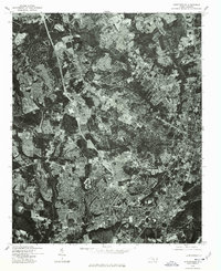
 1976 Vander1978 Print · USGSFayetteville and its eastern outskirts are captured in the mid-seventies, showing the intersection of urban growth and rural landscapes. Researchers can trace land use patterns and property boundaries near Fayetteville and the settlement of Vander.
 - 1976 Map of Fayetteville, 1978 Print
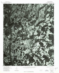
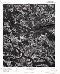
 1976 Fayetteville1978 Print · USGSMid-1970s Cumberland County is documented in this detailed aerial survey showing the rapid suburban growth of the era. Researchers can trace the exact layout of residential streets and land clearing around Fayetteville, Bonnie Doone, and Lakedale.
 - 1976 Map of Slocomb, 1978 Print
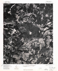 1976 Slocomb1978 Print · USGSCumberland County rural life is captured in the mid-seventies just as the landscape remained defined by timber and traditional farming. Genealogists and land researchers can pinpoint homesteads and property boundaries near the Cape Fear River, Slocomb, and Lane.
 - 1976 Map of Clifdale, 1978 Print
 1976 Clifdale1978 Print · USGSThe area around Clifdale during the mid-seventies is captured here through detailed orthophotography. Genealogists and historians can trace property lines and land use near Clifdale, Caisson Hill, and Route 401.
 - 1976 Map of Parkton, 1978 Print
 1976 Parkton1978 Print · USGSRobeson County agricultural life is frozen in the mid-1970s in this detailed aerial study. Researchers can pinpoint property boundaries and rural development surrounding the towns of Parkton, Lumber Bridge, and Rockfish.
 - 1976 Map of Manchester, 1978 Print
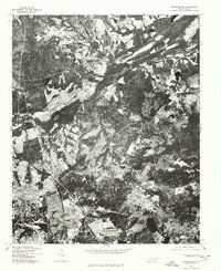 1976 Manchester1978 Print · USGSThe Fort Bragg military post and nearby Manchester are captured in this mid-seventies aerial survey. Researchers can trace the development of Fort Bragg and explore the residential layouts of Manchester and Twin Lakes.
End of results
Showing maps 1-7 of 7
Top cities near Fayetteville
- Linden Oaks historical maps
- Hope Mills historical maps
- Spring Lake historical maps
- Stedman historical maps
- Wade historical maps
- Parkton historical maps
See more
Top neighborhoods of Fayetteville
- Englewood historical maps
- Beaver Creek historical maps
- Haymount historical maps
- Skibo historical maps
- Hillendale historical maps
- South Hills historical maps
See more
Frequently asked questions
- What are the different types of historical maps available for Fayetteville?
- What is the oldest map of Fayetteville?
- Where can I purchase historical maps of Fayetteville for my home or office?
- Where can I download high-res historical maps of Fayetteville?
- Are there historical topographic maps available for Fayetteville?
- Is there historical aerial imagery available for Fayetteville?
- Where are historical maps of Fayetteville sourced from?