1940s Maps of Fayetteville, North Carolina
Explore 5 historic maps of Fayetteville from the 1940s. These maps offer a rare glimpse into what life looked like during the 1940s — showing old roads, neighborhoods, homes, and landmarks that have changed or disappeared over time.
Whether you're researching your family's past, planning a metal detecting trip, or studying how Fayetteville's landscape evolved across the 1940s, these high-resolution maps are a powerful tool for exploring the history of this region.
- Focus on a specific era: All maps on this page are from the 1940s, giving you a focused view of this time period.
- See what’s changed: Compare century-old streets, trails, and buildings to today's modern landscape using overlays and satellite layers.
- Research with precision: Use these maps for genealogy, historical research, land use analysis, or educational projects.
- View, download, or print: Maps are fully viewable online in high resolution, and can be downloaded or printed for your own records.
Start exploring Fayetteville's history through authentic maps from the 1940s. This is your window into the past.
Fayetteville, NC maps
(5)- 1948 Map of Fayetteville, 1954 Print
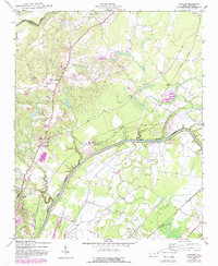
 1948 Fayetteville1954 Print · USGSFayetteville and its sprawling military neighbor are caught here just after the war, showing the area's mix of urban growth and rural heritage. Genealogists can locate family landmarks like Bonnie Doone and Magnolia Ch, or trace the rails of the Atlantic Coast Line.
 - 1948 Map of Clifdale, 1967 Print
 1948 Clifdale1967 Print · USGSHoke and Cumberland Counties appear just after World War II, showing the vast footprint of the Fort Bragg Military Reservation. Local historians can trace old community landmarks like Longstreet Church, the Atlantic Coast Line railroad, and the Frys Mission School.
 - 1948 Map of Slocomb, 1982 Print
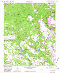
 1948 Slocomb1982 Print · USGSCumberland County's river valleys are captured here in the late forties, showing a landscape of small churches and rail lines. Trace family roots at Palestine Church or the Long Hill School, and follow the old routes of the Norfolk Southern.2 unique versions available
 - 1948 Map of Clifdale, 1983 Print
 1948 Clifdale1983 Print · USGSCumberland County at the midpoint of the century shows a unique transition between military land and residential growth. Genealogists and historians can trace family locations near Galatia Church, the Aberdeen and Rockfish line, and the Caisson Hill Cem.
 - 1949 Map of Vander
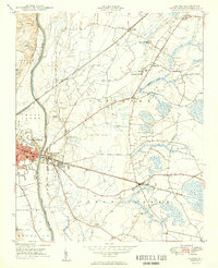 1949 Vander1949 Print · USGSCumberland County just after the war reveals a landscape of rural schoolhouses and busy rail junctions east of the Cape Fear River. Researchers can locate family landmarks like Armstrong School, Lebanon Missionary Church, and the timber works at Vander.2 unique versions available
End of results
Showing maps 1-5 of 5
Top cities near Fayetteville
- Linden Oaks historical maps
- Hope Mills historical maps
- Spring Lake historical maps
- Stedman historical maps
- Wade historical maps
- Parkton historical maps
See more
Top neighborhoods of Fayetteville
- Englewood historical maps
- Beaver Creek historical maps
- Haymount historical maps
- Skibo historical maps
- Hillendale historical maps
- South Hills historical maps
See more
Frequently asked questions
- What are the different types of historical maps available for Fayetteville?
- What is the oldest map of Fayetteville?
- Where can I purchase historical maps of Fayetteville for my home or office?
- Where can I download high-res historical maps of Fayetteville?
- Are there historical topographic maps available for Fayetteville?
- Is there historical aerial imagery available for Fayetteville?
- Where are historical maps of Fayetteville sourced from?