1900s (20th Century) Maps of Corolla, North Carolina
Explore 10 historic maps of Corolla from the 1900s (20th Century). These maps offer a rare glimpse into what life looked like during the 1900s — showing old roads, neighborhoods, homes, and landmarks that have changed or disappeared over time.
Whether you're researching your family's past, planning a metal detecting trip, or studying how Corolla's landscape evolved across the 1900s, these high-resolution maps are a powerful tool for exploring the history of this region.
- Focus on a specific era: All maps on this page are from the 1900s, giving you a focused view of this time period.
- See what’s changed: Compare century-old streets, trails, and buildings to today's modern landscape using overlays and satellite layers.
- Research with precision: Use these maps for genealogy, historical research, land use analysis, or educational projects.
- View, download, or print: Maps are fully viewable online in high resolution, and can be downloaded or printed for your own records.
Start exploring Corolla's history through authentic maps from the 1900s. This is your window into the past.
Corolla, NC maps
(10)- 1940 Map of Barco
 1940 Barco1940 Print · USGSThe Currituck Banks and mainland North Carolina appear here during the early 1940s, highlighting a landscape of remote maritime villages and essential coastal navigation. Researchers can trace the Inland Waterway past Coinjock or locate early landmarks like the Currituck Beach Lighthouse and Poyner Hill C. G. Sta.2 unique versions available
 - 1940 Map of Powells Point
 1940 Powells Point1940 Print · USGSThe North Carolina coast at the start of the 1940s shows the Currituck peninsula just as the Wright Memorial Bridge opened it to more travel. Trace family roots and old landings in Jarvisburg, Powells Point, and Sawyers Lodge.2 unique versions available
 - 1946 Map of Eastville, 1971 Print
 1946 Eastville1971 Print · USGSCoastal Virginia and the Outer Banks are captured here during a period of expanding naval and aerospace presence. Researchers can trace the path of the Penn Central railroad through Chincoteague and Modest Town, or locate landmarks like the Wright Brothers National Memorial.
 - 1946 Map of Currituck Sound, 1980 Print
 1946 Currituck Sound1980 Print · USGSThe Virginia and North Carolina coastline appears in detail during the mid-twentieth century as a network of maritime villages and military outposts. Genealogists and local historians can trace family locations from Virginia Beach south to Kitty Hawk, including landmarks like the Currituck Beach Lighthouse and the Wright Brothers National Memorial.
 - 1961 Map of Eastville
 1961 Eastville1961 Print · USGSThe Eastern Shore and Outer Banks are captured here in the mid-twentieth century, showing a maritime landscape of lighthouses, rail-linked towns, and naval outposts. Researchers can trace the Pennsylvania Railroad through Parksley or locate historical sites like Chincoteague Field Naval Auxiliary Air Station and Tangier Island.
 - 1966 Map of Eastville
 1966 Eastville1966 Print · USGSThe Delmarva Peninsula and Outer Banks appear in the mid-sixties, showing a landscape of maritime trade, military outposts, and fishing villages. Researchers can trace the lines of the Norfolk & Southern through Exmore and Parksley or locate historical sites like Fort John Custis and the Janes Island Lighthouse.
 - 1982 Map of Jarvisburg, 1983 Print
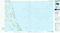
 1982 Jarvisburg1983 Print · USGSThe Currituck Banks and mainland neck are captured in the early eighties as coastal development began to accelerate. Genealogists and researchers can locate numerous community landmarks, from Hebron Ch to the small settlements of Olds and Mamie.
 - 1982 Map of Mossey Islands, 1983 Print
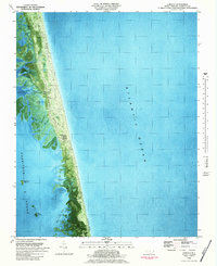
 1982 Mossey Islands1983 Print · USGSThe North Carolina Outer Banks are captured in the early eighties as a complex network of marshes and migrating dunes. Genealogists and historians can trace the remote landscape of the Pine Island Club, Peters Quarter, and the waterfowl ponds around Swan Island.
 - 1982 Map of Corolla, 1983 Print
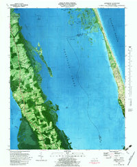
 1982 Corolla1983 Print · USGSThe Outer Banks of Currituck County appear in this early 1980s orthophotomap as a delicate thread between the sea and the sound. Local historians can trace the foundations of Corolla and the prominent Currituck Beach Lighthouse amidst the marshy reaches of Raccoon Bay.2 unique versions available
 - 1985 Map of Currituck Sound
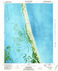
 1985 Currituck Sound1985 Print · USGSThe Outer Banks and Currituck Sound are documented in the mid-1980s, during a period of steady coastal growth and preservation. Researchers can locate long-standing maritime landmarks like the Currituck Beach Lighthouse and trace the original footprints of settlements from Corolla to Kitty Hawk.2 unique versions available
End of results
Showing maps 1-10 of 10
Top cities near Corolla
- Kitty Hawk historical maps
- Grandy historical maps
- Southern Shores historical maps
- Duck historical maps
- Coinjock historical maps
Top neighborhoods of Corolla
- Ocean Hills historical maps
- Crown Point historical maps
- Monterey Shores historical maps
- Ocean Sands South historical maps
- Ocean Sands North historical maps
- Pine Island historical maps
See more
Frequently asked questions
- What are the different types of historical maps available for Corolla?
- What is the oldest map of Corolla?
- Where can I purchase historical maps of Corolla for my home or office?
- Where can I download high-res historical maps of Corolla?
- Are there historical topographic maps available for Corolla?
- Is there historical aerial imagery available for Corolla?
- Where are historical maps of Corolla sourced from?