1940s Maps of Davidson County, North Carolina
Explore 4 historic maps of Davidson County from the 1940s. These maps offer a rare glimpse into what life looked like during the 1940s — showing old roads, neighborhoods, homes, and landmarks that have changed or disappeared over time.
Whether you're researching your family's past, planning a metal detecting trip, or studying how Davidson County's landscape evolved across the 1940s, these high-resolution maps are a powerful tool for exploring the history of this region.
- Focus on a specific era: All maps on this page are from the 1940s, giving you a focused view of this time period.
- See what’s changed: Compare century-old streets, trails, and buildings to today's modern landscape using overlays and satellite layers.
- Research with precision: Use these maps for genealogy, historical research, land use analysis, or educational projects.
- View, download, or print: Maps are fully viewable online in high resolution, and can be downloaded or printed for your own records.
Start exploring Davidson County's history through authentic maps from the 1940s. This is your window into the past.
Davidson County, NC maps
(4)- 1949 Map of High Rock
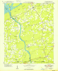 1949 High Rock1949 Print · USGSDavidson County in the late 1940s is defined by the winding Yadkin River and its rural church communities. Researchers can trace ancestral connections through family-named crossings like Bringle Ferry or find local landmarks such as Lick Creek Ch and Bald Mtn.2 unique versions available
 - 1949 Map of Denton NW
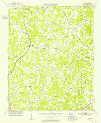
 1949 Denton NW1949 Print · USGSDavidson County’s rural heartland is captured here in the late 1940s as farm life centered around crossroads like Silver Hill. Researchers can locate several country churches including New Jerusalem Ch and Mt View Ch, or trace the rail line near Snider Mill.2 unique versions available
 - 1949 Map of Eller, 1952 Print
 1949 Eller1952 Print · USGSDavidson County in the late 1940s was a landscape of farmsteads and rural parishes connected by winding creek-side roads. Genealogists and local historians can locate specific community hubs like Midway School, Gum Tree, and churches such as Bethlehem Church or Hebron Church.2 unique versions available
 - 1949 Map of High Point West, 1952 Print
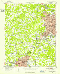 1949 High Point West1952 Print · USGSMid-century development connects High Point and Thomasville as the Southern railroad drives industrial and residential growth. Researchers can find many family-named landmarks and local schools like Ada Blair Sch, Finch Field, and the Conrad Memorial Ch Cem.2 unique versions available
End of results
Showing maps 1-4 of 4
Top cities of Davidson County
- Thomasville historical maps
- Lexington historical maps
- Midway historical maps
- Welcome historical maps
- Tyro historical maps
- Wallburg historical maps
See more
Frequently asked questions
- What are the different types of historical maps available for Davidson County?
- What is the oldest map of Davidson County?
- Where can I purchase historical maps of Davidson County for my home or office?
- Where can I download high-res historical maps of Davidson County?
- Are there historical topographic maps available for Davidson County?
- Is there historical aerial imagery available for Davidson County?
- Where are historical maps of Davidson County sourced from?