Old Maps of Davidson County, North Carolina for Hiking & Exploration
Hike through history with 137 historic maps of Davidson County. Explore old trails, ghost towns, and forgotten backroads — perfect for outdoor adventurers and local explorers.
- Rediscover forgotten places: Map out old mining camps, roads, and footpaths that no longer exist on modern maps.
- Layer with modern tools: Combine with LiDAR or satellite views to plan hikes through historical terrain.
- Made for exploration: Popular among hikers, overlanders, and local history lovers.
Use these maps to find adventure and explore the hidden past of Davidson County.
Davidson County, NC maps
(137)- 1949 Map of High Rock
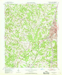
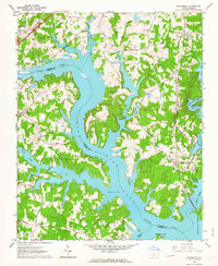
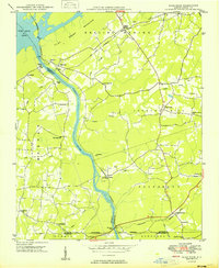 1949 High Rock1949 Print · USGSDavidson County in the late 1940s is defined by the winding Yadkin River and its rural church communities. Researchers can trace ancestral connections through family-named crossings like Bringle Ferry or find local landmarks such as Lick Creek Ch and Bald Mtn.2 unique versions available
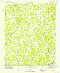
 - 1949 Map of Denton NW
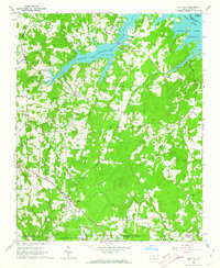
 1949 Denton NW1949 Print · USGSDavidson County’s rural heartland is captured here in the late 1940s as farm life centered around crossroads like Silver Hill. Researchers can locate several country churches including New Jerusalem Ch and Mt View Ch, or trace the rail line near Snider Mill.2 unique versions available
 - 1949 Map of Eller, 1952 Print
 1949 Eller1952 Print · USGSDavidson County in the late 1940s was a landscape of farmsteads and rural parishes connected by winding creek-side roads. Genealogists and local historians can locate specific community hubs like Midway School, Gum Tree, and churches such as Bethlehem Church or Hebron Church.2 unique versions available
 - 1949 Map of High Point West, 1952 Print
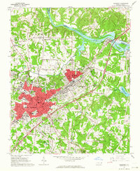
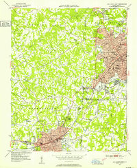 1949 High Point West1952 Print · USGSMid-century development connects High Point and Thomasville as the Southern railroad drives industrial and residential growth. Researchers can find many family-named landmarks and local schools like Ada Blair Sch, Finch Field, and the Conrad Memorial Ch Cem.2 unique versions available
 - 1950 Map of Lexington East, 1965 Print
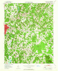 1950 Lexington East1965 Print · USGSDavidson County at mid-century shows a landscape of growing towns and established rural crossroads before major highway expansions. Genealogists can trace family landmarks like Old Becks Ch, the County Home, and the former Dunbar Sch.4 unique versions available
 - 1950 Map of Winston-Salem East, 1965 Print
 1950 Winston-Salem East1965 Print · USGSMid-century Winston-Salem is captured here during its post-war growth, showing the city's eastern neighborhoods and surrounding rural crossroads. Genealogists and historians can trace institutional roots at State Teachers College and find family-named churches like New Friendship Church.5 unique versions available
 - 1950 Map of Lexington West, 1969 Print
 1950 Lexington West1969 Print · USGSWestern Davidson County at the mid-century shows a landscape of growing mill towns and rural communities. Genealogists can trace family landmarks like Erlanger, Robbins Sch, and Pauls Chapel along the Southern railroad line.3 unique versions available
 - 1950 Map of Churchland, 1973 Print
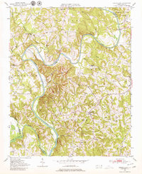 1950 Churchland1973 Print · USGSThe banks of the Yadkin River at the Davidson and Davie county lines are captured here at mid-century. Researchers can trace rural schoolhouse locations and family landmarks like Union Chapel Sch, Grubb Cem, and the village of Churchland.3 unique versions available
 - 1951 Map of Winston-Salem East
 1951 Winston-Salem East1951 Print · USGSMid-century Forsyth County shows the expansion of Winston-Salem toward Kernersville during a period of significant institutional and industrial growth. Researchers can locate local landmarks like Salem College, trace the Southern rail lines, and find rural centers such as Waughtown and Friedland Ch.
 - 1951 Map of Churchland
 1951 Churchland1951 Print · USGSNorth Carolina's central river valleys are detailed here in the early 1950s, showing the rural communities along the Yadkin River. Researchers can locate family landmarks like the Grubb Cemetery and schools such as St Johns Sch and Union Chapel Sch.
 - 1951 Map of Lexington East
 1951 Lexington East1951 Print · USGSDavidson County at mid-century reveals a landscape of rural crossroads and growing industry south of the main rail corridors. Researchers can trace ancestral locations at Old Becks Ch, locate the State Prison Camp No 602, or study the early shoreline of High Rock Lake.
 - 1951 Map of Lexington West
 1951 Lexington West1951 Print · USGSMid-century Davidson County comes alive in this survey of western Lexington and the surrounding townships during a period of steady post-war growth. Researchers can trace the footprints of communities like Erlanger and Reeds Crossroads or locate family sites at Owens Cemetery and Pauls Chapel.
 - 1951 Map of Fair Grove, 1952 Print
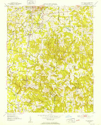 1951 Fair Grove1952 Print · USGSDavidson County in the early fifties is mapped here as a network of rail-side stations and rural parish life. Genealogists can locate family landmarks like Hannersville Station, Loflin Store, and Clarksbury Ch along the historic rail corridors.4 unique versions available
 - 1953 Map of Charlotte, 1968 Print
 1953 Charlotte1968 Print · USGSThe North Carolina Piedmont and South Carolina borderlands are shown in detail during a period of significant growth and reservoir development. Trace the rail corridors of the Southern Railway or find family roots in towns like China Grove, Misenheimer, and Lincolnton.3 unique versions available
 - 1953 Map of Winston-Salem, 1974 Print
 1953 Winston-Salem1974 Print · USGSThe North Carolina Piedmont and Virginia highlands meet in the mid-1950s, a landscape defined by the tobacco and textile hubs of the Blue Ridge foothills. Researchers can trace the rail-and-river geography connecting Winston-Salem to mountain towns like Mount Airy and Galax.2 unique versions available
 - 1954 Map of Charlotte
 1954 Charlotte1954 Print · USGSThe North Carolina Piedmont in the mid-1950s shows a region of rapid growth and industrial expansion centered around Charlotte. Trace the era's infrastructure through the Southern railroad lines and locate significant landmarks like the Charlotte Naval Ammunition Depot and Lake Norman.2 unique versions available
 - 1955 Map of Winston-Salem
 1955 Winston-Salem1955 Print · USGSThe Central Blue Ridge and Piedmont transition are captured here in the mid-fifties, from the industrial hub of Winston-Salem to the high peaks of Southwest Virginia. Genealogists can trace family landmarks like Richmond Hill Ch, Siloam Ch, and the old rail stops along the Southern Railway.
 - 1957 Map of Denton, 1958 Print
 1957 Denton1958 Print · USGSIn the foothills of Davidson County during the late fifties, rural life centered on the banks of the Yadkin and the local rail lines. Researchers can trace family sites like Jackson Hill, rural congregations at New Jerusalem Ch, and the workings of the Silver Mine.
 - 1960 Map of Charlotte
 1960 Charlotte1960 Print · USGSMid-century North Carolina and South Carolina meet in this 1960 survey of the Piedmont's industrial and textile heartland. Trace the growth of Charlotte alongside historic landmarks like Kings Mountain National Military Park and the Charlotte Naval Ammunition Depot.2 unique versions available
 - 1962 Map of Winston-Salem
 1962 Winston-Salem1962 Print · USGSThe North Carolina Piedmont meets the Virginia highlands in the early sixties, showing the rail corridors and mountain gaps of the southern Appalachians. Researchers can trace the Blue Ridge Parkway or locate family sites near Winston-Salem, Mount Airy, and Hanging Rock Mountain.
 - 1962 Map of Charlotte
 1962 Charlotte1962 Print · USGSThe North Carolina Piedmont in the early sixties showcases a landscape transformed by massive reservoirs and industrial growth. Researchers can trace the development of Lake Norman, locate the Charlotte Naval Ammunition Depot, or find family landmarks like Wesley Chapel and Brown & Norcott Mills.
 - 1962 Map of Southmont, 1964 Print
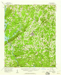
 1962 Southmont1964 Print · USGSThe Yadkin River valley in the early 1960s reveals a landscape transformed by the waters of High Rock Lake. Genealogists and local historians can trace the foundations of riverside life through landmarks like Trading Ford, Southmont, and Rising Star Church.3 unique versions available
 - 1962 Map of Salisbury, 1964 Print
 1962 Salisbury1964 Print · USGSSalisbury and its rail corridors are shown here in the early sixties, as the city expanded around its historic colleges and industrial hubs. Researchers can trace family roots through numerous sites like National Cem, Catawba College, and the old crossroads at Trading Ford.3 unique versions available
 - 1962 Map of Gold Hill, 1964 Print
 1962 Gold Hill1964 Print · USGSRowan County in the early sixties remains a landscape of quiet crossroads and riverside communities along the Yadkin River. Genealogists can trace family names and community roots through landmarks like St Peters Cem, Gold Hill Ch, and the settlement at Agner.3 unique versions available
 - 1969 Map of Kernersville, 1972 Print
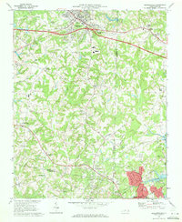 1969 Kernersville1972 Print · USGSThe Piedmont Triad takes shape in the late sixties as Kernersville and High Point begin to grow together. Genealogists and historians can trace the foundations of local communities at Beeson Crossroads, Southern Pilgrim College, and Union Cross.3 unique versions available
Showing maps 1-25 of 137
Top cities of Davidson County
- Thomasville historical maps
- Lexington historical maps
- Midway historical maps
- Welcome historical maps
- Tyro historical maps
- Wallburg historical maps
See more
Frequently asked questions
- What are the different types of historical maps available for Davidson County?
- What is the oldest map of Davidson County?
- Where can I purchase historical maps of Davidson County for my home or office?
- Where can I download high-res historical maps of Davidson County?
- Are there historical topographic maps available for Davidson County?
- Is there historical aerial imagery available for Davidson County?
- Where are historical maps of Davidson County sourced from?