1940s Maps of Londonberry Estates, North Carolina
Explore 1 historic maps of Londonberry Estates from the 1940s. These maps offer a rare glimpse into what life looked like during the 1940s — showing old roads, neighborhoods, homes, and landmarks that have changed or disappeared over time.
Whether you're researching your family's past, planning a metal detecting trip, or studying how Londonberry Estates's landscape evolved across the 1940s, these high-resolution maps are a powerful tool for exploring the history of this region.
- Focus on a specific era: All maps on this page are from the 1940s, giving you a focused view of this time period.
- See what’s changed: Compare century-old streets, trails, and buildings to today's modern landscape using overlays and satellite layers.
- Research with precision: Use these maps for genealogy, historical research, land use analysis, or educational projects.
- View, download, or print: Maps are fully viewable online in high resolution, and can be downloaded or printed for your own records.
Start exploring Londonberry Estates's history through authentic maps from the 1940s. This is your window into the past.
Londonberry Estates, NC maps
(1)- 1949 Map of High Point West, 1952 Print
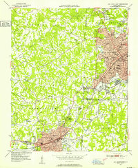 1949 High Point West1952 Print · USGSMid-century development connects High Point and Thomasville as the Southern railroad drives industrial and residential growth. Researchers can find many family-named landmarks and local schools like Ada Blair Sch, Finch Field, and the Conrad Memorial Ch Cem.2 unique versions available
End of results
Showing maps 1-1 of 1
Top cities near Londonberry Estates
- Greensboro historical maps
- Winston-Salem historical maps
- High Point historical maps
- Thomasville historical maps
- Asheboro historical maps
- Kernersville historical maps
See more
Frequently asked questions
- What are the different types of historical maps available for Londonberry Estates?
- What is the oldest map of Londonberry Estates?
- Where can I purchase historical maps of Londonberry Estates for my home or office?
- Where can I download high-res historical maps of Londonberry Estates?
- Are there historical topographic maps available for Londonberry Estates?
- Is there historical aerial imagery available for Londonberry Estates?
- Where are historical maps of Londonberry Estates sourced from?