
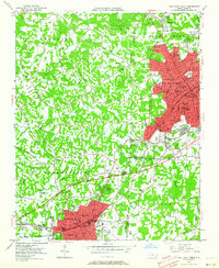
1949 Map of High Point West
USGS Topo · Published 1952About this map
The industrial corridor between High Point and Thomasville is dominated by the Southern railroad and the winding course of Rich Fork. This late-1940s landscape shows the rapid expansion of these furniture and textile hubs, with residential areas like Oakview and Erwin Heights filling the gaps between established town centers. The map reveals a high density of community institutions, including numerous neighborhood schools such as Johnson St Sch and Ray Street Sch, alongside central landmarks like the High Point Hospital and City Hall.
Find a feature on this map
71 named features on this map. Tap any name to fly to it.
Don’t see what you’re looking for? This feature index may not catch every label — zoom into the map to look around manually.
Map Details
Editions of this 1949 High Point West Map
2 editions found
Other maps of this area

1949 · Eller
USGS Topo · 1:24,000

1950 · High Point East
USGS Topo · 1:24,000

1950 · Lexington East
USGS Topo · 1:24,000

1950 · Winston-Salem East
USGS Topo · 1:24,000

1951 · Winston-Salem East
USGS Topo · 1:24,000

1951 · Lexington East
USGS Topo · 1:24,000

1951 · High Point East
USGS Topo · 1:24,000

1951 · Guilford
USGS Topo · 1:24,000

1951 · Fair Grove
USGS Topo · 1:24,000

1953 · Raleigh
USGS Topo · 1:250,000