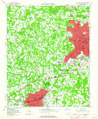
1949 Map of High Point West
USGS Topo · Published 1964About this map
The urban cores of High Point and Thomasville dominate this late 1940s landscape, illustrating the industrial and residential growth along the Southern Ry corridor. This era finds both cities densely packed with community institutions, including an extensive network of neighborhood schools like Johnson St Sch, Ray Street Sch, and Oak Hill Sch. The development patterns reflect a mid-century shift as residential areas expand toward the Emerywood Country Club, while the surrounding rural spaces remain defined by small agricultural settlements and country churches such as Springhill Ch and Zion Ch.
Find a feature on this map
57 named features on this map. Tap any name to fly to it.
Don’t see what you’re looking for? This feature index may not catch every label — zoom into the map to look around manually.
Map Details
Editions of this 1949 High Point West Map
2 editions found
Other maps of this area

1949 · Eller
USGS Topo · 1:24,000

1949 · High Point West
USGS Topo · 1:24,000

1950 · High Point East
USGS Topo · 1:24,000

1950 · Lexington East
USGS Topo · 1:24,000

1950 · Winston-Salem East
USGS Topo · 1:24,000

1951 · Winston-Salem East
USGS Topo · 1:24,000

1951 · Lexington East
USGS Topo · 1:24,000

1951 · High Point East
USGS Topo · 1:24,000

1951 · Guilford
USGS Topo · 1:24,000

1951 · Fair Grove
USGS Topo · 1:24,000