1900s (20th Century) Maps of Warsaw, North Carolina
Explore 10 historic maps of Warsaw from the 1900s (20th Century). These maps offer a rare glimpse into what life looked like during the 1900s — showing old roads, neighborhoods, homes, and landmarks that have changed or disappeared over time.
Whether you're researching your family's past, planning a metal detecting trip, or studying how Warsaw's landscape evolved across the 1900s, these high-resolution maps are a powerful tool for exploring the history of this region.
- Focus on a specific era: All maps on this page are from the 1900s, giving you a focused view of this time period.
- See what’s changed: Compare century-old streets, trails, and buildings to today's modern landscape using overlays and satellite layers.
- Research with precision: Use these maps for genealogy, historical research, land use analysis, or educational projects.
- View, download, or print: Maps are fully viewable online in high resolution, and can be downloaded or printed for your own records.
Start exploring Warsaw's history through authentic maps from the 1900s. This is your window into the past.
Warsaw, NC maps
(10)- 1953 Map of Florence, 1964 Print
 1953 Florence1964 Print · USGSThe Carolina borderlands in the mid-fifties were a landscape of vast river swamps and rising rail towns. Trace the legacy of the Seaboard Air Line through Florence or explore the wetlands surrounding Lake Waccamaw and the Green Swamp.3 unique versions available
 - 1953 Map of Raleigh, 1965 Print
 1953 Raleigh1965 Print · USGSCentral North Carolina in the early sixties shows a landscape of growing towns and military hubs before the full expansion of the interstate system. Genealogists can trace family footprints across the Piedmont through Wake Forest, Siler City, and the large Fort Bragg Military Reservation.4 unique versions available
 - 1954 Map of Florence
 1954 Florence1954 Print · USGSThe Carolinas borderlands come alive in the early fifties, showing the vital rail-and-river networks of the coastal plain. Genealogists can trace family footprints across the Green Swamp or through settlements like Red Springs, Chadbourn, and McColl.
 - 1954 Map of Raleigh
 1954 Raleigh1954 Print · USGSThe North Carolina Piedmont and Sandhills are captured in the mid-fifties during a period of steady regional growth. Genealogists and historians can trace the development of towns like Siler City or locate landmarks such as Falls of Neuse and Camp Mackall.
 - 1962 Map of Rose Hill, 1964 Print
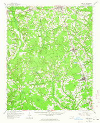 1962 Rose Hill1964 Print · USGSCoastal plain life in the early sixties centers on the rail-aligned towns of Rose Hill and Warsaw. Genealogists and local historians can locate dozens of country churches and schools, from Holly Grove Ch to the Williams Sch, alongside the Rose Hill Speedway.
 - 1977 Map of Warsaw North
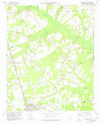 1977 Warsaw North1977 Print · USGSDuplin County in the late seventies is captured here as a landscape of rural hamlets and swamp drainage networks. Genealogists and historians can trace family locations through numerous country churches like Sanford Ch, old railroad infrastructure, and the streets of Warsaw.
 - 1982 Map of Elizabethtown, 1983 Print
 1982 Elizabethtown1983 Print · USGSSoutheastern North Carolina's coastal plain is captured here in the early eighties, showcasing a landscape defined by the Cape Fear River and mysterious Carolina Bays. Genealogists and researchers can trace the rail network of the Seaboard Coast Line through rural communities like Autryville, Ivanhoe, and the recreational hub of White Lake.
 - 1984 Map of Warsaw South
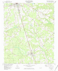 1984 Warsaw South1984 Print · USGSCoastal plain Duplin County is mapped here in the early eighties, showcasing a landscape of railroad towns and rural parishes. Genealogists can trace family landmarks like Rose Hill Cem, St Stephens Ch, and the small settlement of Carroll.
 - 1984 Map of Turkey
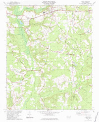 1984 Turkey1984 Print · USGSCoastal plain settlements in Sampson County are mapped here in the early eighties, showing a landscape shaped by the SEABOARD rail line and numerous creek branches. Researchers can trace rural church history and family sites at St Stephens Ch, Piney Grove Ch, and Moltonville.
 - 1986 Map of Fayetteville
 1986 Fayetteville1986 Print · USGSThe North Carolina coastal plain appears in the mid-1980s as a bustling corridor of military installations and historic tobacco towns. Genealogists and historians can trace the footprints of Fort Bragg Military Reservation, Campbell University, and the rail lines of the Seaboard Coast Line RR.2 unique versions available
End of results
Showing maps 1-10 of 10
Top cities near Warsaw
- Clinton historical maps
- Mount Olive historical maps
- Rose Hill historical maps
- Magnolia historical maps
- Kenansville historical maps
- Faison historical maps
See more
Frequently asked questions
- What are the different types of historical maps available for Warsaw?
- What is the oldest map of Warsaw?
- Where can I purchase historical maps of Warsaw for my home or office?
- Where can I download high-res historical maps of Warsaw?
- Are there historical topographic maps available for Warsaw?
- Is there historical aerial imagery available for Warsaw?
- Where are historical maps of Warsaw sourced from?