1970s Maps of Youngsville, North Carolina
Explore 2 historic maps of Youngsville from the 1970s. These maps offer a rare glimpse into what life looked like during the 1970s — showing old roads, neighborhoods, homes, and landmarks that have changed or disappeared over time.
Whether you're researching your family's past, planning a metal detecting trip, or studying how Youngsville's landscape evolved across the 1970s, these high-resolution maps are a powerful tool for exploring the history of this region.
- Focus on a specific era: All maps on this page are from the 1970s, giving you a focused view of this time period.
- See what’s changed: Compare century-old streets, trails, and buildings to today's modern landscape using overlays and satellite layers.
- Research with precision: Use these maps for genealogy, historical research, land use analysis, or educational projects.
- View, download, or print: Maps are fully viewable online in high resolution, and can be downloaded or printed for your own records.
Start exploring Youngsville's history through authentic maps from the 1970s. This is your window into the past.
Youngsville, NC maps
(2)- 1978 Map of Franklinton
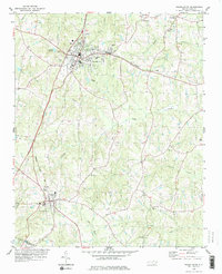 1978 Franklinton1978 Print · USGSFranklin County in the late seventies reveals a landscape shaped by the rail corridor connecting Franklinton and Youngsville. Researchers can trace rural lineages through numerous country churches like Oak Level Ch and family landmarks at Mitchiners Crossroads.2 unique versions available
 - 1978 Map of Grissom
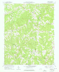 1978 Grissom1978 Print · USGSThe intersection of Granville, Wake, and Franklin counties comes into focus in the late 1970s, showing a rural landscape defined by creek-side settlements. Genealogists can trace family roots through numerous small churches and cemeteries like Kinchen Chapel, Marys Chapel, and Purnell.2 unique versions available
End of results
Showing maps 1-2 of 2
Top cities near Youngsville
- Raleigh historical maps
- Wake Forest historical maps
- Wendell historical maps
- Zebulon historical maps
- Knightdale historical maps
- Louisburg historical maps
See more
Frequently asked questions
- What are the different types of historical maps available for Youngsville?
- What is the oldest map of Youngsville?
- Where can I purchase historical maps of Youngsville for my home or office?
- Where can I download high-res historical maps of Youngsville?
- Are there historical topographic maps available for Youngsville?
- Is there historical aerial imagery available for Youngsville?
- Where are historical maps of Youngsville sourced from?